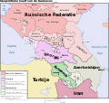
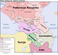
File:Caucasus-political-ru.svg

Size of this PNG preview of this SVG file: 512 × 485 pixels. Other resolutions: 253 × 240 pixels | 507 × 480 pixels | 811 × 768 pixels | 1,081 × 1,024 pixels | 2,162 × 2,048 pixels.
Original file (SVG file, nominally 512 × 485 pixels, file size: 504 KB)
File information
Structured data
Captions
Captions
Add a one-line explanation of what this file represents
Summary
edit| DescriptionCaucasus-political-ru.svg |
English: Geopolitical map of the Caucasus Region. Русский: Геополитическая карта Кавказа. Українська: Геополітична мапа Кавказу, (написи російською мовою). Абхазія та Південна Осетія відмічені штрихуванням, бо анексовані Росією, не зважаючи на рішення РБ ООН і реакцію міжнародної спільноти. |
||||||||
| Date | |||||||||
| Source |
English: Largest part of the borders based on Image:Caucasus-ethnic en.svg by User:Pmx, a vectorization of this CIA map. Former (autonomous oblast) and current (de facto independent republic) borders of Nagorno-Karabakh based on Location_Nagorno-Karabakh_en.png. North coast of Turkey based on Map_of_Turkey_(2007).gif. |
||||||||
| Author | Hayk | ||||||||
| Permission (Reusing this file) |
Hayk, the copyright holder of this work, hereby publishes it under the following licenses:
This file is licensed under the Creative Commons Attribution 2.5 Generic license. Attribution: Hayk
You may select the license of your choice. |
||||||||
| Other versions |
This map is a translation of Image:Caucasus-political nl.svg
[edit]
|
| This SVG file contains embedded text that can be translated into your language, using any capable SVG editor, text editor or the SVG Translate tool. For more information see: About translating SVG files. |
This W3C-unspecified vector image was created with Inkscape .
File history
Click on a date/time to view the file as it appeared at that time.
| Date/Time | Thumbnail | Dimensions | User | Comment | |
|---|---|---|---|---|---|
| current | 14:28, 11 July 2024 |  | 512 × 485 (504 KB) | Toghrul R (talk | contribs) | updated per 2020 and 2023 Karabakh wars |
| 15:31, 20 January 2020 |  | 972 × 922 (371 KB) | Takhirgeran Umar (talk | contribs) | clarification | |
| 05:03, 27 April 2018 |  | 972 × 922 (370 KB) | Kentronhayastan (talk | contribs) | Updated "Nagorno-Karabakh" to "Artsakh," the new official name of the self-proclaimed republic. | |
| 12:59, 12 June 2011 |  | 972 × 922 (370 KB) | Hayk (talk | contribs) | == {{int:filedesc}} == {{Information |Description={{Multilingual description|en=Geopolitical map of the Caucasus Region.|ru=Геополитическая карта Кавказа.}} |Source={{en|Largest part of the |
You cannot overwrite this file.
File usage on Commons
The following 21 pages use this file:
- User:Magog the Ogre/Multilingual legend/2024 July 9-12
- File:Caucasus-political-fr.svg
- File:Caucasus-political-krc.svg
- File:Caucasus-political-ru.svg
- File:Caucasus-political-tr.svg
- File:Caucasus-political (hy).png
- File:Caucasus-political Fa.svg
- File:Caucasus-political ca.svg
- File:Caucasus-political cs.svg
- File:Caucasus-political de.svg
- File:Caucasus-political en.svg
- File:Caucasus-political es.svg
- File:Caucasus-political ja.svg
- File:Caucasus-political mk.svg
- File:Caucasus-political mzn.svg
- File:Caucasus-political nl.svg
- File:Caucasus-political pl.svg
- File:Caucasus-political pt.svg
- File:Caucasus-political vi.svg
- File:Kaukasian geopoliittinen kartta.svg
- Template:Other versions/Caucasus-political
File usage on other wikis
The following other wikis use this file:
- Usage on ady.wikipedia.org
- Usage on kbd.wikipedia.org
- Usage on os.wikipedia.org
- Usage on sah.wikipedia.org
- Usage on tt.wikipedia.org
- Usage on uk.wikipedia.org
Metadata
This file contains additional information such as Exif metadata which may have been added by the digital camera, scanner, or software program used to create or digitize it. If the file has been modified from its original state, some details such as the timestamp may not fully reflect those of the original file. The timestamp is only as accurate as the clock in the camera, and it may be completely wrong.
| Width | 100% |
|---|---|
| Height | 100% |


