File:Karte völkerwanderung.jpg

Size of this preview: 800 × 530 pixels. Other resolutions: 320 × 212 pixels | 640 × 424 pixels | 1,000 × 663 pixels.
Original file (1,000 × 663 pixels, file size: 116 KB, MIME type: image/jpeg)
File information
Structured data
Captions
Captions
Add a one-line explanation of what this file represents
Summary
edit| DescriptionKarte völkerwanderung.jpg |
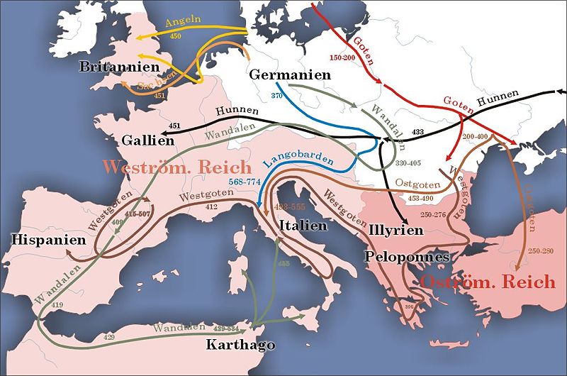
Deutsch: Darstellung zeigt die Völkerwanderungen im Europa vom zweiten bis fünften Jahrhundert nach Christus. English: Map shows the migrations in Europa from 150 till 500 AD
Lëtzebuergesch: Kaart vun der Vollekswanderung |
| Date | |
| Source | German Wikipedia |
| Author | Sansculotte |
| Permission (Reusing this file) |
GFDL Deutsch: Quellenangabe und Beleg an sansculotte@despammed.com erbeten. English: Please quote source and send an notice to sansculotte@despammed.com |

|
This historical map image could be re-created using vector graphics as an SVG file. This has several advantages; see Commons:Media for cleanup for more information. If an SVG form of this image is available, please upload it and afterwards replace this template with
{{vector version available|new image name}}.
It is recommended to name the SVG file “Karte völkerwanderung.svg”—then the template Vector version available (or Vva) does not need the new image name parameter. |
This historical map image was uploaded in the JPEG format even though it consists of non-photographic data. This information could be stored more efficiently or accurately in the PNG or SVG format. If possible, please upload a PNG or SVG version of this image without compression artifacts, derived from a non-JPEG source (or with existing artifacts removed). After doing so, please tag the JPEG version with {{Superseded|NewImage.ext}} and remove this tag. This tag should not be applied to photographs or scans. If this image is a diagram or other image suitable for vectorisation, please tag this image with {{Convert to SVG}} instead of {{BadJPEG}}. If not suitable for vectorisation, use {{Convert to PNG}}. For more information, see {{BadJPEG}}. |
History (from de.wikipedia.org)
edit(Löschen) (Aktuell) 02:44, 17. Feb 2004 . . Sansculotte (Diskussion) . . 1000 x 663 (118.439 Byte) (eigene Darstellung, 08/2003 A. Darmochwal. Karte ist im Sinne der GNU FDL frei verwendbar. Quellenangabe und Beleg erbeten.)
Licensing
edit
|
Permission is granted to copy, distribute and/or modify this document under the terms of the GNU Free Documentation License, Version 1.2 or any later version published by the Free Software Foundation; with no Invariant Sections, no Front-Cover Texts, and no Back-Cover Texts. A copy of the license is included in the section entitled GNU Free Documentation License.http://www.gnu.org/copyleft/fdl.htmlGFDLGNU Free Documentation Licensetruetrue |
| This file is licensed under the Creative Commons Attribution-Share Alike 3.0 Unported license. | ||
| ||
| This licensing tag was added to this file as part of the GFDL licensing update.http://creativecommons.org/licenses/by-sa/3.0/CC BY-SA 3.0Creative Commons Attribution-Share Alike 3.0truetrue |
File history
Click on a date/time to view the file as it appeared at that time.
| Date/Time | Thumbnail | Dimensions | User | Comment | |
|---|---|---|---|---|---|
| current | 12:40, 13 December 2005 |  | 1,000 × 663 (116 KB) | Dbachmann (talk | contribs) | Darstellung zeigt die Völkerwanderungen im Europa vom zweiten bis fünften Jahrhundert nach Christus. Zeichnung erstellt 08/2003 von de:Benutzer:Sansculotte. Bild ist unter der GNU FDL zur weiteren Verwendung freigegeben. '''Quellenangabe und Bele |
You cannot overwrite this file.
File usage on Commons
The following 29 pages use this file:
- Atlas of Albania
- Atlas of Algeria
- Atlas of Austria
- Atlas of Bosnia and Herzegovina
- Atlas of Bulgaria
- Atlas of Croatia
- Atlas of European history
- Atlas of France
- Atlas of Galicia
- Atlas of Greece
- Atlas of Hungary
- Atlas of Kosovo
- Atlas of Luxembourg
- Atlas of Malta
- Atlas of Montenegro
- Atlas of Morocco
- Atlas of North Macedonia
- Atlas of Portugal
- Atlas of Serbia
- Atlas of Slovenia
- Atlas of Spain
- Atlas of Tunisia
- Atlas of Turkey
- Atlas of ancient Rome
- Atlas of the Byzantine Empire
- Atlas of the Middle Ages
- Maps of Switzerland
- Top 200 JPG images that should use vector graphics
- User:Ultrogothe
File usage on other wikis
The following other wikis use this file:
- Usage on af.wikipedia.org
- Usage on als.wikipedia.org
- Usage on an.wikipedia.org
- Usage on bar.wikipedia.org
- Usage on bg.wikipedia.org
- Карл Велики
- Германи
- Шаблон:Монарх
- Лотар I
- Лудвиг II (Италия)
- Албоин
- Вахо
- Аудоин
- Валтари
- Агелмунд
- Ламисио
- Херцози и крале на лангобардите
- Тато (лангобард)
- Айо
- Ибор и Айо
- Клафо
- Годеок
- Летук
- Хилдеок
- Клеф
- Аутари
- Гримоалд I (Беневенто)
- Агилулф
- Адалоалд
- Ариоалд
- Ротари (лангобард)
- Родоалд
- Ариперт I
- Годеперт
- Перктарит
- Кунинкперт
- Лиутперт
- Рагинперт
- Ариперт II
- Теодолинда
- Гарибалд
- Анспранд
- Лиутпранд (лангобард)
- Хилдепранд
- Ратчис
- Айзтулф
View more global usage of this file.
