File:Map of Yosemite National Park.svg

Size of this PNG preview of this SVG file: 692 × 599 pixels. Other resolutions: 277 × 240 pixels | 554 × 480 pixels | 887 × 768 pixels | 1,183 × 1,024 pixels | 2,365 × 2,048 pixels | 746 × 646 pixels.
Original file (SVG file, nominally 746 × 646 pixels, file size: 313 KB)
File information
Structured data
Captions
Captions
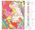
Geological map of Yosemite National Park and vicinity
Summary
edit| DescriptionMap of Yosemite National Park.svg | Map of Yosemite National Park based on a map by the USGS image from here. Original notes that the data was "generalized from geological map of Yosemite National Park and vicinity (Huber and others, in press)" and that "an intrusive suite is a grouping of genetically related plutonic rocks". |
| Date | (UTC) |
| Source |
This file was derived from: General geologic map of Yosemite area.png: |
| Author | |
| Other versions | Derivative works of this file: Map of Cathedral Peak Granodiorite.svg |
Licensing
editThis file is licensed under the Creative Commons Attribution-Share Alike 3.0 Unported license.
- You are free:
- to share – to copy, distribute and transmit the work
- to remix – to adapt the work
- Under the following conditions:
- attribution – You must give appropriate credit, provide a link to the license, and indicate if changes were made. You may do so in any reasonable manner, but not in any way that suggests the licensor endorses you or your use.
- share alike – If you remix, transform, or build upon the material, you must distribute your contributions under the same or compatible license as the original.
Original upload log
editThis image is a derivative work of the following images:
- File:General_geologic_map_of_Yosemite_area.png licensed with PD-USGov-USGS
- 2007-03-03T15:24:43Z Urban 734x666 (741890 Bytes) [[Category:Yosemite National Park]] uploaded from : http://en.wikipedia.org/wiki/Image:General_geologic_map_of_Yosemite_area.png PD USGS image from http://geology.wr.usgs.gov/docs/usgsnps/yos/yosmap.html {{PD-USGov-USGS}}
Uploaded with derivativeFX
File history
Click on a date/time to view the file as it appeared at that time.
| Date/Time | Thumbnail | Dimensions | User | Comment | |
|---|---|---|---|---|---|
| current | 22:07, 25 May 2012 |  | 746 × 646 (313 KB) | Grandiose (talk | contribs) | Hopefully restore rivers |
| 21:25, 23 May 2012 |  | 746 × 646 (1.27 MB) | Grandiose (talk | contribs) | == {{int:filedesc}} == {{Information |Description=uploaded from : http://en.wikipedia.org/wiki/Image:General_geologic_map_of_Yosemite_area.png Other version: File:Cathedral Peak Granodiorit.png PD USGS image from http://geology.wr.usgs.gov/docs/... |
You cannot overwrite this file.
File usage on Commons
The following page uses this file:
File usage on other wikis
The following other wikis use this file:
- Usage on en.wikipedia.org
- Yosemite National Park
- Geology of the Yosemite area
- Wikipedia:Featured picture candidates/May-2012
- Wikipedia:Featured picture candidates/Map of Yosemite National Park
- Tuolumne Intrusive Suite
- Fine Gold Intrusive Suite
- Intrusive Suite of Buena Vista Crest
- Intrusive Suite of Yosemite Valley
- Intrusive Suite of Sonora Pass
- Intrusive Suite of Merced Peak
- Usage on mt.wikipedia.org
- Usage on nl.wikipedia.org
- Usage on sl.wikipedia.org
- Usage on zh.wikipedia.org