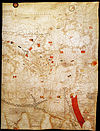
File:Portolan chart of Guillem Soler (c.1380, Paris).jpg

Original file (16,908 × 10,882 pixels, file size: 24.64 MB, MIME type: image/jpeg)
Captions
Captions
Summary
edit| Warning | The original file is very high-resolution. It might not load properly or could cause your browser to freeze when opened at full size. | Open in ZoomViewer |
|---|
| Guillem Soler: Català: Guillmus Soleri civis maioricaru me fecit
( |
|||||||||||||||||||||||||||
|---|---|---|---|---|---|---|---|---|---|---|---|---|---|---|---|---|---|---|---|---|---|---|---|---|---|---|---|
| Artist |
artist QS:P170,Q3651379 |
||||||||||||||||||||||||||
| Title |
Català: Guillmus Soleri civis maioricaru me fecit |
||||||||||||||||||||||||||
| Description |
English: Portolan chart signed by Majorcan cartographer Guillem Soler (Guillelmus Soleri, Guglielmo Soleri) but undated (est. c.1380, but could be anywhere between 1368 and 1385), held by the Bibliothèque nationale de France in Paris, France.
Français : Carte marine de l'océan Atlantique Est, de la mer Méditerranée, de la mer Noire et de la mer Rouge / Guillmus Soleri civjs maioric[arum] me fecit |
||||||||||||||||||||||||||
| Date |
1380 date QS:P571,+1380-00-00T00:00:00Z/9 |
||||||||||||||||||||||||||
| Dimensions |
height: 65 cm (25.5 in); width: 102 cm (40.1 in) dimensions QS:P2048,65U174728 dimensions QS:P2049,102U174728 |
||||||||||||||||||||||||||
| Collection |
institution QS:P195,Q193563 |
||||||||||||||||||||||||||
| Current location |
Paris |
||||||||||||||||||||||||||
| Accession number |
CPL GE B-1131 (RES) |
||||||||||||||||||||||||||
| Source/Photographer |
Bibliothèque nationale de France |
||||||||||||||||||||||||||
| Other versions |
|
||||||||||||||||||||||||||
Licensing
edit| This file might NOT be in the public domain. It was previously considered to be in the public domain because it is a scan (or similar) by the Bibliotheque Nationale de France, but not everything scanned by the BNF is automatically in the public domain. It is possible that this file is in the public domain for other reasons, for example because it was published a long time ago (anything before ca. 1900 is most likely ok) or because its author / artist / photographer died over 70 years ago and it was published over 95 years ago. In such cases, a new rationale should be applied, and a different license tag (see Commons:Licensing and valid license tags at Commons:Copyright tags) should be used. If the file is not found to be in the public domain, it might be nominated for deletion (NOT by any automatic process, but manually). |
Previous public domain rationale, no longer applicable
| |||
|---|---|---|---|
|
|
This is a faithful photographic reproduction of a two-dimensional, public domain work of art. The work of art itself is in the public domain for the following reason:
The official position taken by the Wikimedia Foundation is that "faithful reproductions of two-dimensional public domain works of art are public domain".
This photographic reproduction is therefore also considered to be in the public domain in the United States. In other jurisdictions, re-use of this content may be restricted; see Reuse of PD-Art photographs for details. | |||||
File history
Click on a date/time to view the file as it appeared at that time.
| Date/Time | Thumbnail | Dimensions | User | Comment | |
|---|---|---|---|---|---|
| current | 01:24, 7 February 2021 |  | 16,908 × 10,882 (24.64 MB) | One2 (talk | contribs) | hq |
| 13:17, 17 July 2011 |  | 5,587 × 3,552 (8.15 MB) | Walrasiad (talk | contribs) | Larger resolution file | |
| 18:43, 19 June 2011 |  | 576 × 357 (70 KB) | Walrasiad (talk | contribs) | {{Information |Description ={{en|1=Portolan chart signed by Majorcan cartographer [w:Guillem Soler|Guillem Soler]] (Guillelmus Soleri, Guglielmo Soleri) but undated (est. c.1380, but could be anywhere between 1368 and 1385), held by the Bibliothè |
You cannot overwrite this file.
File usage on Commons
The following 10 pages use this file:
- User:Magog the Ogre/Multilingual legend/2021 February 1-9
- User:One2/Mapas subidos
- File:Eastern Mediterranean detail of portolan chart of Guillem Soler (c.1380, Paris).jpg
- File:Flag of the Second Bulgarian Empire.svg
- File:Península Ibérica no portolano de Guillem Soler (c. 1380).jpg
- File:Portolan chart of Guillem Soler (c.1380, Paris).jpg
- File:Portolan chart of Guillem Soler (c.1380, Paris) Black Sea.jpg
- File:Portolan chart of Guillem Soler (c.1380, Paris) Egypt.jpg
- File:Portolan chart of Guillem Soler (c.1380, Paris) Europe.jpg
- File:Portolan chart of Guillem Soler (c.1380, Paris) Israel.jpg
File usage on other wikis
The following other wikis use this file:
- Usage on ca.wikipedia.org
- Usage on en.wikipedia.org
- Usage on fr.wikipedia.org
- Usage on uk.wikipedia.org
- Usage on www.wikidata.org


