A Comparative Study of the Applied Methods for Estimating Deflection of the Vertical in Terrestrial Geodetic Measurements
- PMID: 27104544
- PMCID: PMC4851079
- DOI: 10.3390/s16040565
A Comparative Study of the Applied Methods for Estimating Deflection of the Vertical in Terrestrial Geodetic Measurements
Abstract
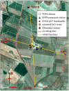
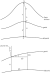
This paper compares three different methods capable of estimating the deflection of the vertical (DoV): one is based on the joint use of high precision spirit leveling and Global Navigation Satellite Systems (GNSS), a second uses astro-geodetic measurements and the third gravimetric geoid models. The working data sets refer to the geodetic International Terrestrial Reference Frame (ITRF) co-location sites of Medicina (Northern, Italy) and Noto (Sicily), these latter being excellent test beds for our investigations. The measurements were planned and realized to estimate the DoV with a level of precision comparable to the angular accuracy achievable in high precision network measured by modern high-end total stations. The three methods are in excellent agreement, with an operational supremacy of the astro-geodetic method, being faster and more precise than the others. The method that combines leveling and GNSS has slightly larger standard deviations; although well within the 1 arcsec level, which was assumed as threshold. Finally, the geoid model based method, whose 2.5 arcsec standard deviations exceed this threshold, is also statistically consistent with the others and should be used to determine the DoV components where local ad hoc measurements are lacking.
Keywords: ITALGEO2005; ITRF; QDaedalus; deflection of the vertical; tie vectors.
Figures


Similar articles
-
Precise Geoid Determination in the Eastern Swiss Alps Using Geodetic Astronomy and GNSS/Leveling Methods.Sensors (Basel). 2024 Nov 2;24(21):7072. doi: 10.3390/s24217072. Sensors (Basel). 2024. PMID: 39517969 Free PMC article.
-
A Direct Georeferencing Method for Terrestrial Laser Scanning Using GNSS Data and the Vertical Deflection from Global Earth Gravity Models.Sensors (Basel). 2017 Jun 24;17(7):1489. doi: 10.3390/s17071489. Sensors (Basel). 2017. PMID: 28672795 Free PMC article.
-
Modernizing and Expanding the NASA Space Geodesy Network to Meet Future Geodetic Requirements.J Geod. 2019 Nov;93(11):2263-2273. doi: 10.1007/s00190-018-1204-5. J Geod. 2019. PMID: 31920223 Free PMC article.
-
Geodetic and Remote-Sensing Sensors for Dam Deformation Monitoring.Sensors (Basel). 2018 Oct 29;18(11):3682. doi: 10.3390/s18113682. Sensors (Basel). 2018. PMID: 30380693 Free PMC article. Review.
-
Estimating renal function in children: a new GFR-model based on serum cystatin C and body cell mass.Dan Med J. 2012 Jul;59(7):B4486. Dan Med J. 2012. PMID: 22759853 Review.
Cited by
-
Height Variation Depending on the Source of Antenna Phase Centre Corrections: LEIAR25.R3 Case Study.Sensors (Basel). 2019 Sep 17;19(18):4010. doi: 10.3390/s19184010. Sensors (Basel). 2019. PMID: 31533316 Free PMC article.
References
-
- Carosio A., Reis O. Geodetic Methods and Mathematical Models for the Establishment of New Trans-Alpine Transportation Routes. Institut für Geodäsie und Photogrammetrie an der Eidg. Technischen Hochschule; Zurich, Switzerland: 1996.
-
- Gervaise J., Mayoud M., Beutler G., Gurtner W. Test of GPS on the CERN-LEP control network; Proceedings of Joint Meeting of FIG Study Groups 5B and 5C on Inertial, Doppler and GPS Measurements for National and Engineering Surveys; Munich, Germany. 1–3 July 1985; pp. 337–358.
-
- Ingensand H., Ryf A., Stengele R. The Gotthard Base Tunnel-a challenge for geodesy and geotechnics; Proceedings of Symposium on Geodesy for Geotechnical and Structural Engineering; Eisenstadt, Austria. 20–22 April 1998.
-
- Featherstone W.E., Rüeger J.M. The importance of using deviations of the vertical for the reduction of survey data to a geocentric datum. Aust. Surv. 2000;45:46–61. doi: 10.1080/00050354.2000.10558815. - DOI
-
- Vanicek P., Krakiwsky E. Geodesy: The Concepts. North-Holland Publishing Co.; Amsterdam, The Netherlands: 1982.
LinkOut - more resources
Full Text Sources
Other Literature Sources
Miscellaneous

