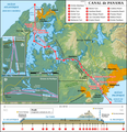
Datei:Panama Canal Map DE.png

Greßi vu däre Vorschau: 581 × 600 Pixel. Wyteri Ufflösige: 232 × 240 Pixel | 465 × 480 Pixel | 744 × 768 Pixel | 992 × 1.024 Pixel | 2.191 × 2.262 Pixel.
Originaldatei (2.191 × 2.262 Pixel, Dateigrößi: 3,5 MB, MIME-Typ: image/png)
Dateiversione
Klick uf e Zytpunkt zu aazeige, wie s dert usgsäh het.
| Version vom | Vorschaubild | Mäß | Benutzer | Kommentar | |
|---|---|---|---|---|---|
| aktuell | 16:50, 3. Okt. 2021 |  | 2.191 × 2.262 (3,5 MB) | Thoroe | + Puente Atlántico |
| 00:04, 16. Feb. 2017 |  | 2.191 × 2.262 (3,62 MB) | Thoroe | Update | |
| 23:36, 30. Mär. 2014 |  | 1.294 × 1.336 (1,67 MB) | Kopiersperre | optipng | |
| 12:21, 1. Jun. 2012 |  | 1.294 × 1.336 (1,85 MB) | Thoroe | Minor fixes and improvements | |
| 14:25, 30. Mai 2012 |  | 1.294 × 1.336 (1,85 MB) | Thoroe | {{Information |Description ={{en|1=Map of the Panama Canal (German version)}} {{de|1=Karte des Panamakanals (Deutsche Version)}} |Source ={{own}} Map created using: *[http://gmt.soest.hawaii.edu Gene... |
Verwändig vu dr Datei
Di folgende Sytene händ en Link zu dem Bildli:
Wältwyti Dateinutzig
Die andere Wikis bruche die Datei:
- Gebruch uf de.wikipedia.org
- Gebruch uf de.wikivoyage.org
- Gebruch uf frr.wikipedia.org
- Gebruch uf nds.wikipedia.org
- Gebruch uf stq.wikipedia.org


