Fitxer:Watkins Glen International Circuit Map.png

Fitxer original (999 × 503 píxels, mida del fitxer: 148 Ko, tipus MIME: image/png)

Descripció a Commons
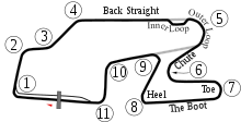
Descripció New version based on Image:Watkins_Glen_International_Track_Map.svg with white borders on some objects in case the background isn't white. New version adds the bus stop. The PNG version was updated for users of browsers like IE7 that don't support SVG.
Data 6-5-2008
Font Created by User:Will Pittenger with Inkscape
Autor User:Will Pittenger
Permís
(Com reutilitzar aquest fitxer)
Public domain S'ha alliberat aquesta obra al domini públic pel seu autor Will Pittenger. Això s'aplica a tot el món.

En alguns països això pot no ser legalment possible, en tal cas:
Will Pittenger concedeix a tothom el dret d'usar aquesta obra per a qualsevol propòsit, sense cap condició llevat d'aquelles requerides per la llei.

Altres versions
SVG Version used to build this version of the PNG file
Posició de la càmera42° 20′ 10,8″ N, 76° 55′ 27″ O Kartographer map based on OpenStreetMap.Aquesta i altres imatges properes a: OpenStreetMapinfo
File:Watkins Glen International Track Map.svg és una versió vectorial (SVG) d'aquest fitxer. En cas de ser millor, hauria de ser emprada en lloc d'aquesta imatge tramada.

File:Watkins Glen International Circuit Map.png → File:Watkins Glen International Track Map.svg

Per a més informació pel que fa als gràfics vectorials, llegiu la transició a SVG en Commons.
També hi ha informació quant a la compatibilitat del MediaWiki amb les imatges SVG.

En altres idiomes
Alemannisch  العربية  беларуская (тарашкевіца)  български  বাংলা  català  нохчийн  čeština  dansk  Deutsch  Ελληνικά  English  British English  Esperanto  español  eesti  euskara  فارسی  suomi  français  Frysk  galego  Alemannisch  עברית  hrvatski  magyar  հայերեն  Bahasa Indonesia  Ido  italiano  日本語  ქართული  한국어  lietuvių  македонски  മലയാളം  Bahasa Melayu  norsk bokmål  Plattdüütsch  Nederlands  norsk nynorsk  norsk  occitan  polski  prūsiskan  português  português do Brasil  română  русский  sicilianu  Scots  slovenčina  slovenščina  српски / srpski  svenska  தமிழ்  ไทย  Türkçe  татарча / tatarça  українська  vèneto  Tiếng Việt  中文  中文(中国大陆)  中文(简体)  中文(繁體)  中文(马来西亚)  中文(新加坡)  中文(臺灣)  中文(臺灣)  +/−
Nova imatge SVG

Llegendes

Afegeix una explicació d'una línia del que representa aquest fitxer

Elements representats en aquest fitxer

representa l'entitat

42°20'10.799"N, 76°55'27.001"W

Historial del fitxer

Cliqueu una data/hora per veure el fitxer tal com era aleshores.

Data/horaMiniaturaDimensionsUsuari/aComentari
actual23:37, 15 oct 2009Miniatura per a la versió del 23:37, 15 oct 2009999 × 503 (148 Ko)Spyder MonkeyCorrected turn numbers and names (inner loop, outer loop)
06:22, 6 juny 2008Miniatura per a la versió del 06:22, 6 juny 2008999 × 509 (148 Ko)Will Pittenger{{Information |Description=New version based on Image:Watkins_Glen_International_Track_Map.svg with white borders on some objects in case the background isn't white. New version adds the bus stop. The PNG version was updated for users of browsers l
19:23, 29 nov 2006Miniatura per a la versió del 19:23, 29 nov 2006470 × 490 (20 Ko)AconcaguaWatkins Glen International Circuit Map {{Moved to commons|lt|Arz|21:42, 2006 Rugpjūčio 3}} {{PD-user-lt|Arz}} Category:Formula One circuits maps

La pàgina següent utilitza aquest fitxer:

Ús global del fitxer

Metadades

  NODES
INTERN 14
Project 3
USERS 2