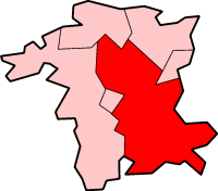
Category:Wychavon District
local government district in Worcestershire, England | |||||
| Upload media | |||||
| Instance of | |||||
|---|---|---|---|---|---|
| Location | Worcestershire, West Midlands, England | ||||
| Capital | |||||
| Legislative body |
| ||||
| Population |
| ||||
| Area |
| ||||
| official website | |||||
 | |||||
Subcategories
This category has the following 93 subcategories, out of 93 total.
Media in category "Wychavon District"
The following 56 files are in this category, out of 56 total.
-
34046 "Braunton" Wyre Piddle Worcestershire. - panoramio.jpg 1,629 × 1,080; 856 KB
-
5043 on the Welsh Marches Express - panoramio.jpg 3,776 × 2,520; 3.42 MB
-
Canal - panoramio (18).jpg 2,816 × 2,112; 2.49 MB
-
Canal along Hanbury Rd - panoramio (1).jpg 2,816 × 2,112; 2.71 MB
-
Canal along Hanbury Rd - panoramio (2).jpg 2,816 × 2,112; 2.65 MB
-
Canal along Hanbury Rd - panoramio (3).jpg 2,816 × 2,112; 3.06 MB
-
Canal along Hanbury Rd - panoramio (4).jpg 2,816 × 2,112; 2.77 MB
-
Canal along Hanbury Rd - panoramio (5).jpg 2,816 × 2,112; 2.52 MB
-
Canal along Hanbury Rd - panoramio (6).jpg 2,816 × 2,112; 2.76 MB
-
Canal along Hanbury Rd - panoramio (7).jpg 2,816 × 2,112; 2.57 MB
-
Canal along Hanbury Rd - panoramio (8).jpg 2,816 × 2,112; 2.46 MB
-
Canal along Hanbury Rd - panoramio (9).jpg 2,816 × 2,112; 2.98 MB
-
Canal along Hanbury Rd - panoramio.jpg 2,816 × 2,112; 2.63 MB
-
Cottedge - panoramio.jpg 2,816 × 2,112; 2.95 MB
-
Droitwich - panoramio (3).jpg 2,773 × 1,748; 2.43 MB
-
Droitwich - panoramio (4).jpg 2,816 × 2,112; 2.59 MB
-
Droitwich - panoramio (5).jpg 2,271 × 1,590; 1.34 MB
-
Earl of Mount Edgecombe on the Cotswold Explorer - panoramio.jpg 3,475 × 1,906; 2.37 MB
-
Effortlessly uploaded by Eye-Fi - panoramio (1).jpg 4,032 × 2,272; 2.1 MB
-
Effortlessly uploaded by Eye-Fi - panoramio (2).jpg 4,032 × 2,272; 1.97 MB
-
Effortlessly uploaded by Eye-Fi - panoramio.jpg 4,032 × 2,272; 2.09 MB
-
Hanbury, UK - panoramio (2).jpg 4,176 × 2,784; 3.81 MB
-
Hanbury, UK - panoramio.jpg 2,816 × 2,112; 1.72 MB
-
Inside the grounds of the Firs - panoramio.jpg 2,576 × 1,932; 1.54 MB
-
Megachilidae. - Flickr - gailhampshire (1).jpg 2,912 × 2,568; 374 KB
-
Megachilidae. - Flickr - gailhampshire (2).jpg 2,528 × 2,288; 484 KB
-
Megachilidae. - Flickr - gailhampshire.jpg 2,778 × 2,286; 446 KB
-
Melanostoma mellinum - Flickr - gailhampshire.jpg 1,266 × 1,070; 224 KB
-
Mesembrina meridiana - Flickr - gailhampshire.jpg 1,792 × 1,469; 575 KB
-
Migrant Hawker. Aeshna mixta. Immature male. - Flickr - gailhampshire (1).jpg 1,296 × 1,340; 354 KB
-
OCM 053 (2).jpg 3,508 × 2,480; 4.43 MB
-
Old House Farm - geograph.org.uk - 1015101.jpg 640 × 480; 105 KB
-
Old House Farm, Whittington - geograph.org.uk - 1083340.jpg 640 × 426; 109 KB
-
Oliver Cromwell 70013 at Abbotswood . - panoramio.jpg 2,894 × 1,246; 1.54 MB
-
Oliver Cromwell at Wadborough - panoramio.jpg 3,711 × 2,380; 5.15 MB
-
Platform view of the station in August 2018.jpg 1,953 × 3,004; 1.18 MB
-
Road - panoramio (125).jpg 1,936 × 1,936; 1.62 MB
-
St Peter's garden centre - geograph.org.uk - 857797.jpg 640 × 480; 120 KB
-
Stourport on Severn - panoramio (28).jpg 2,816 × 2,112; 2.74 MB
-
Stourport on Severn - panoramio (29).jpg 2,816 × 2,112; 2.67 MB
-
Stourport on Severn - panoramio (30).jpg 2,816 × 2,112; 3.12 MB
-
Stourport on Severn - panoramio (32).jpg 2,816 × 2,112; 3.18 MB
-
Sunset Whittington Tump fro The Firs - panoramio (1).jpg 4,032 × 2,272; 1.53 MB
-
Sunset Whittington Tump fro The Firs - panoramio (2).jpg 4,032 × 2,272; 1.75 MB
-
Sunset Whittington Tump fro The Firs - panoramio (3).jpg 4,032 × 2,272; 1.08 MB
-
Sunset Whittington Tump fro The Firs - panoramio (4).jpg 4,032 × 2,272; 1.04 MB
-
Sunset Whittington Tump fro The Firs - panoramio (5).jpg 4,032 × 2,272; 2.06 MB
-
Sunset Whittington Tump fro The Firs - panoramio (6).jpg 4,032 × 2,272; 1.26 MB
-
The District of Wychavon - geograph.org.uk - 521531.jpg 640 × 426; 104 KB
-
The Firs - panoramio (1).jpg 2,048 × 1,536; 1.05 MB
-
The Firs - panoramio (2).jpg 4,032 × 2,272; 1.47 MB
-
The Firs - panoramio.jpg 2,048 × 1,536; 1.21 MB
-
The Firs Lookig to Footbridge - panoramio.jpg 4,032 × 3,024; 1.98 MB
-
The Firs Looking out to M5 - panoramio.jpg 4,032 × 3,024; 1.8 MB
-
Worcester Hospital - panoramio.jpg 4,032 × 3,024; 1.77 MB
-
Wychavon UK ward map 2023.svg 633 × 720; 499 KB


