File:1french-empire1811.jpg

Original file (2,247 × 1,798 pixels, file size: 1.58 MB, MIME type: image/jpeg)
Captions
Captions

|
This old map image could be re-created using vector graphics as an SVG file. This has several advantages; see Commons:Media for cleanup for more information. If an SVG form of this image is available, please upload it and afterwards replace this template with
{{vector version available|new image name}}.
It is recommended to name the SVG file “1french-empire1811.svg”—then the template Vector version available (or Vva) does not need the new image name parameter. |
This old map image was uploaded in the JPEG format even though it consists of non-photographic data. This information could be stored more efficiently or accurately in the PNG or SVG format. If possible, please upload a PNG or SVG version of this image without compression artifacts, derived from a non-JPEG source (or with existing artifacts removed). After doing so, please tag the JPEG version with {{Superseded|NewImage.ext}} and remove this tag. This tag should not be applied to photographs or scans. If this image is a diagram or other image suitable for vectorisation, please tag this image with {{Convert to SVG}} instead of {{BadJPEG}}. If not suitable for vectorisation, use {{Convert to PNG}}. For more information, see {{BadJPEG}}. |
Summary
edit
|
This map has been uploaded by Electionworld from en.wikipedia.org to enable the |
| Description1french-empire1811.jpg |
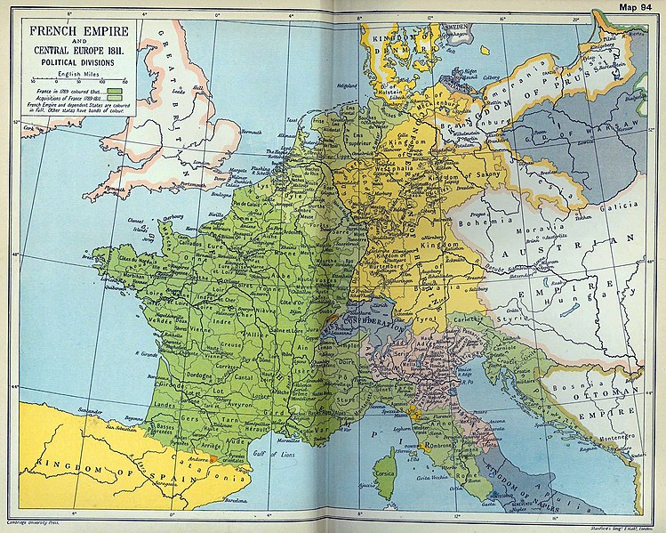
English: French Empire and Central Europe in 1811 (Political Divisions). |
|||||
| Date | ||||||
| Source | Cambridge Modern History Atlas, 1912; Perry-Castañeda Library Map Collection. | |||||
| Creator |
Sir Adolphus William Ward, G.W. Prothero, Sir Stanley Mordaunt Leathes, and E.A. Benians. |
|||||
| Permission (Reusing this file) |
See also: Perry-Castañeda Library's usage statement.
|
|||||
| Georeferencing | Georeference the map in Wikimaps Warper If inappropriate please set warp_status = skip to hide. | |||||
| Other versions |
 |
|||||
File history
Click on a date/time to view the file as it appeared at that time.
| Date/Time | Thumbnail | Dimensions | User | Comment | |
|---|---|---|---|---|---|
| current | 18:43, 19 September 2018 |  | 2,247 × 1,798 (1.58 MB) | 1970gemini (talk | contribs) | geautobalanced |
| 18:37, 10 September 2011 |  | 2,247 × 1,798 (1.76 MB) | P. S. Burton (talk | contribs) | slight crop | |
| 18:06, 8 September 2010 |  | 2,249 × 1,805 (1.01 MB) | DIREKTOR (talk | contribs) | cleanup | |
| 15:06, 3 December 2006 |  | 2,249 × 1,805 (980 KB) | Electionworld (talk | contribs) | {{ew|en|Themanwithoutapast}} Map of Europe in 1811 (French Empire) taken from the 1912 Cambridge Modern History Atlas source: http://www.lib.utexas.edu/usage_statement.html {{PD-old}} Category:Maps of the history of France |
You cannot overwrite this file.
File usage on Commons
The following 12 pages use this file:
File usage on other wikis
The following other wikis use this file:
- Usage on bg.wikipedia.org
- Usage on br.wikipedia.org
- Usage on de.wikipedia.org
- Usage on el.wikipedia.org
- Usage on en.wikipedia.org
- Usage on es.wikipedia.org
- Usage on et.wikipedia.org
- Usage on fr.wikipedia.org
- Usage on gl.wikipedia.org
- Usage on he.wikipedia.org
- Usage on hr.wikipedia.org
- Usage on hu.wikipedia.org
- Usage on id.wikipedia.org
- Usage on it.wikipedia.org
- Usage on ja.wikipedia.org
- Usage on pl.wikipedia.org
- Usage on pt.wikipedia.org
- Usage on ro.wikipedia.org
- Usage on ru.wikipedia.org
- Usage on sr.wikipedia.org
- Usage on tr.wikipedia.org
- Usage on uk.wikipedia.org
- Usage on uz.wikipedia.org
- Usage on zh.wikipedia.org
Metadata
This file contains additional information such as Exif metadata which may have been added by the digital camera, scanner, or software program used to create or digitize it. If the file has been modified from its original state, some details such as the timestamp may not fully reflect those of the original file. The timestamp is only as accurate as the clock in the camera, and it may be completely wrong.
| Pixel composition | RGB |
|---|---|
| Orientation | Normal |
| Horizontal resolution | 200 dpi |
| Vertical resolution | 200 dpi |
| Software used | Adobe Photoshop CS5 Windows |
| File change date and time | 20:05, 8 September 2010 |
| Exif version | 2.21 |
| Color space | Uncalibrated |
