File:Ancient Egypt map-es.svg

Size of this PNG preview of this SVG file: 293 × 598 pixels. Other resolutions: 117 × 240 pixels | 235 × 480 pixels | 376 × 768 pixels | 501 × 1,024 pixels | 1,003 × 2,048 pixels | 1,577 × 3,219 pixels.
Original file (SVG file, nominally 1,577 × 3,219 pixels, file size: 416 KB)
File information
Structured data
Captions
Captions
Add a one-line explanation of what this file represents
Summary
edit| DescriptionAncient Egypt map-es.svg |
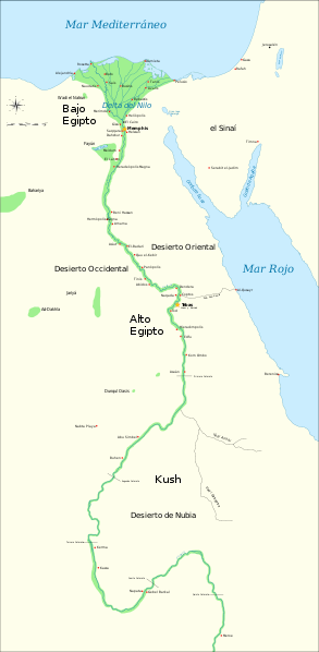
Español: Mapa del Antiguo Egipto, que muestra el Nilo hasta la quinta catarata, y las principales ciudades y sitios del período dinástico (c. 3150 aC al 30 aC). El Cairo y Jerusalén se muestran como las ciudades de referencia. |
| Date | |
| Source | Commons.Derivate:File:Ancient Egypt map-en.svg |
| Author | User:Bibi Saint-Pol, User: Jeff Dahl |
| Other versions |
[edit]
|
Licensing
editThis file is licensed under the Creative Commons Attribution-Share Alike 3.0 Unported license.
- You are free:
- to share – to copy, distribute and transmit the work
- to remix – to adapt the work
- Under the following conditions:
- attribution – You must give appropriate credit, provide a link to the license, and indicate if changes were made. You may do so in any reasonable manner, but not in any way that suggests the licensor endorses you or your use.
- share alike – If you remix, transform, or build upon the material, you must distribute your contributions under the same or compatible license as the original.
File history
Click on a date/time to view the file as it appeared at that time.
| Date/Time | Thumbnail | Dimensions | User | Comment | |
|---|---|---|---|---|---|
| current | 12:31, 4 August 2021 |  | 1,577 × 3,219 (416 KB) | -sasha- (talk | contribs) | corregida confusión entre alto y bajo Egipto |
| 10:09, 2 June 2014 |  | 1,577 × 3,219 (416 KB) | Ortisa (talk | contribs) | User created page with UploadWizard |
You cannot overwrite this file.
File usage on Commons
The following 29 pages use this file:
- User:Magog the Ogre/Multilingual legend/2021 August 1-10
- File:Ancient Egypt map-af.svg
- File:Ancient Egypt map-ar.png
- File:Ancient Egypt map-de.svg
- File:Ancient Egypt map-el.svg
- File:Ancient Egypt map-en.svg
- File:Ancient Egypt map-es.svg
- File:Ancient Egypt map-fr.svg
- File:Ancient Egypt map-hiero.svg
- File:Ancient Egypt map-hy.png
- File:Ancient Egypt map-it.svg
- File:Ancient Egypt map-la.png
- File:Ancient Egypt map-la.svg
- File:Ancient Egypt map-mk.svg
- File:Ancient Egypt map-nl.svg
- File:Ancient Egypt map-no.svg
- File:Ancient Egypt map-pl.svg
- File:Ancient Egypt map-pt.svg
- File:Ancient Egypt map-ru.svg
- File:Ancient Egypt map-sk.svg
- File:Ancient Egypt map-sr.svg
- File:Ancient Egypt map-vi.svg
- File:Ancient Egypt map-zh-hans.svg
- File:Antik Mısır haritası.png
- File:Antzinako Egipto.svg
- File:Mapo de antikva Egiptio.jpg
- File:Mapo de antikva Egiptio - centro.jpg
- File:Muistne Egiptus.png
- Template:Other versions/Ancient Egypt map
Metadata
This file contains additional information such as Exif metadata which may have been added by the digital camera, scanner, or software program used to create or digitize it. If the file has been modified from its original state, some details such as the timestamp may not fully reflect those of the original file. The timestamp is only as accurate as the clock in the camera, and it may be completely wrong.
| Width | 1577.348 |
|---|---|
| Height | 3219.4182 |


