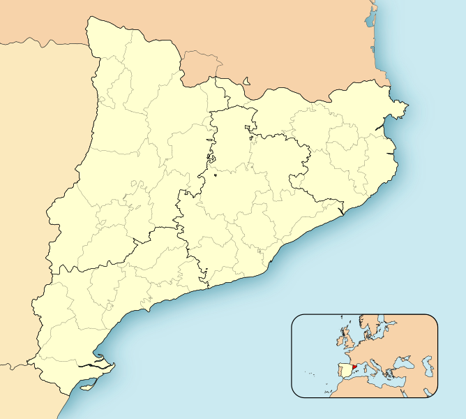
File:CatalunyaLoc.svg

Original file (SVG file, nominally 2,786 × 2,501 pixels, file size: 320 KB)
Captions
Captions
Summary
edit| DescriptionCatalunyaLoc.svg |
Català: Mapa de localització de Catalunya
Projecció equirrectangular, N/S estirada 130%. Límits geogràfics del mapa:
English: Location map of Catalonia
Equirectangular projection, N/S stretching 130 %. Geographic limits of the map:
Español: Mapa de localización de Cataluña
Proyección equirrectangular, N/S estirada 130 %. Límites geográficos del mapa:
|
|||
| Date | ||||
| Source | Own work | |||
| Author | HansenBCN | |||
| Permission (Reusing this file) |
|
|||
| Other versions |
Derivative works of this file: |
|||
| SVG development InfoField | This locator map was created with Inkscape.
|
File history
Click on a date/time to view the file as it appeared at that time.
| Date/Time | Thumbnail | Dimensions | User | Comment | |
|---|---|---|---|---|---|
| current | 12:30, 17 November 2021 |  | 2,786 × 2,501 (320 KB) | Jmarchn (talk | contribs) | better framing |
| 09:34, 27 April 2008 |  | 3,300 × 2,500 (456 KB) | HansenBCN (talk | contribs) | Sombreado de agua descentrado y borde superior eliminado | |
| 14:38, 26 April 2008 |  | 3,300 × 2,500 (453 KB) | HansenBCN (talk | contribs) | Bordes | |
| 14:32, 26 April 2008 |  | 3,300 × 2,500 (453 KB) | HansenBCN (talk | contribs) | == Summary == {{Information |Description=Catalonia Location Map |Source=self-made |Date=26/april/2008 |Author= HansenBCN |Permission= |other_versions=[Image:CatalunyaLoc.png|50px] }} == Licensing == {{PD-self |
You cannot overwrite this file.
File usage on Commons
The following 9 pages use this file:
- CataIonia
- User:Chumwa/OgreBot/Travel and communication maps/2021 November 11-20
- User:Magog the Ogre/Multilingual legend/2021 November 11-20
- File:Catalan Republic location map.svg
- File:Catalonia location map.svg
- File:Independentismo comarcas Cataluña 2011.svg
- File:Independentismo comarcas Cataluña 2012.svg
- File:Provincias de Catalunya.svg
- File:Provincias de Cataluña.svg
File usage on other wikis
The following other wikis use this file:
- Usage on an.wikipedia.org
- Barcelona
- Leida
- Fulleda
- L'Ametlla de Mar
- Archivo d'a Corona d'Aragón
- Vielha e Mijaran
- Tortosa
- Horta de Sant Joan
- Puicerdán
- Tarragona
- Reus
- Chirona
- Sant Sadurní d'Anoia
- Vilafranca del Penedès
- Igualada
- Sabadell
- Berga
- Manresa
- Sant Feliu de Llobregat
- Vilanova i la Geltrú
- Mataró
- Terrassa
- Granollers
- Tàrrega
- Solsona
- Cervera (Leida)
- Mollerussa
- Sort
- Tremp
- Balaguer
- El Pont de Suert
- Vic
- Llessui
- Seu d'Urchel
- Les Borges Blanques
- Valls
- La Bisbal d'Empordà
- El Vendrell
- Montblanc
- Olot
- Amposta
- Agullana
- Banyolas
- Camós
- Cornellà del Terri
- Crespià
- Esponellà
- Fontcoberta
- Palol de Revardit
- Porqueres
View more global usage of this file.
Metadata
This file contains additional information such as Exif metadata which may have been added by the digital camera, scanner, or software program used to create or digitize it. If the file has been modified from its original state, some details such as the timestamp may not fully reflect those of the original file. The timestamp is only as accurate as the clock in the camera, and it may be completely wrong.
| Width | 2786 |
|---|---|
| Height | 2501.3333 |