File:Geocentric vs geodetic latitude.svg

Size of this PNG preview of this SVG file: 600 × 600 pixels. Other resolutions: 240 × 240 pixels | 480 × 480 pixels | 768 × 768 pixels | 1,024 × 1,024 pixels | 2,048 × 2,048 pixels | 792 × 792 pixels.
Original file (SVG file, nominally 792 × 792 pixels, file size: 52 KB)
File information
Structured data
Captions
Captions
Add a one-line explanation of what this file represents
Summary
edit| DescriptionGeocentric vs geodetic latitude.svg |
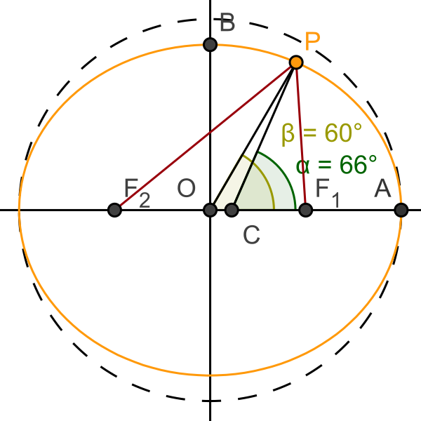
English: Shows the difference between angles of latitude for a position on an oblate spheroid (such as the Earth) when using the geocentric (angle β) and geodetic (angle α) coordinate systems. The segment, IP, bisects the angle GPF, where points G and F are the foci of the elliptical cross-section of the spheroid, and is therefore normal to the ellipse at point P. |
| Date | |
| Source | Own work. Download source code. |
| Author | SharkD |
| Other versions |
|
Licensing
edit| Public domainPublic domainfalsefalse |
| I, the copyright holder of this work, release this work into the public domain. This applies worldwide. In some countries this may not be legally possible; if so: I grant anyone the right to use this work for any purpose, without any conditions, unless such conditions are required by law. |
This vector image was created with GeoGebra by v.
File history
Click on a date/time to view the file as it appeared at that time.
| Date/Time | Thumbnail | Dimensions | User | Comment | |
|---|---|---|---|---|---|
| current | 19:40, 3 March 2021 |  | 792 × 792 (52 KB) | Datumizer (talk | contribs) | Rename some variables. Adjust scale. |
| 21:07, 19 July 2018 |  | 786 × 786 (32 KB) | Datumizer (talk | contribs) | Label the points differently. | |
| 05:36, 6 August 2008 |  | 300 × 300 (38 KB) | Datumizer (talk | contribs) | text too dark | |
| 05:34, 6 August 2008 |  | 300 × 300 (38 KB) | Datumizer (talk | contribs) | removed accidental purple text | |
| 05:33, 6 August 2008 |  | 300 × 300 (38 KB) | Datumizer (talk | contribs) | Image is now more readable | |
| 04:41, 15 February 2008 |  | 500 × 500 (35 KB) | Datumizer (talk | contribs) | Switched to showing the same coordinate with different angles instead of the same angle with different coordinates. | |
| 04:32, 15 February 2008 |  | 500 × 500 (37 KB) | Datumizer (talk | contribs) | Try and get rid of background. | |
| 04:22, 15 February 2008 |  | 500 × 500 (38 KB) | Datumizer (talk | contribs) | {{Information |Description=Shows the difference between latitude coordinates on an oblate spheroid (such as the Earth) when using the geocentric and geodetic coordinate systems. |Source=self-made |Date=2008-02-14 |Author= SharkD |Permissio |
You cannot overwrite this file.
File usage on Commons
The following 3 pages use this file:
File usage on other wikis
The following other wikis use this file:
- Usage on bn.wikipedia.org
- Usage on ca.wikipedia.org
- Usage on el.wikipedia.org
- Usage on en.wikipedia.org
- Usage on ha.wikipedia.org
- Usage on la.wikipedia.org
Metadata
This file contains additional information such as Exif metadata which may have been added by the digital camera, scanner, or software program used to create or digitize it. If the file has been modified from its original state, some details such as the timestamp may not fully reflect those of the original file. The timestamp is only as accurate as the clock in the camera, and it may be completely wrong.
| Width | 792px |
|---|---|
| Height | 792px |

