File:Map of Utah State University RCDE.png

Size of this preview: 464 × 600 pixels. Other resolutions: 186 × 240 pixels | 371 × 480 pixels | 792 × 1,024 pixels.
Original file (792 × 1,024 pixels, file size: 212 KB, MIME type: image/png)
File information
Structured data
Captions
Captions
Add a one-line explanation of what this file represents
Summary
edit| DescriptionMap of Utah State University RCDE.png |
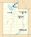
English: A map of the Utah State University Regional Campuses throughout the State of Utah. |
| Date | |
| Source | Own work derived from File:USA_Utah_location_map.svg |
| Author | Jhunt47 |
Licensing
editI, the copyright holder of this work, hereby publish it under the following license:
This file is licensed under the Creative Commons Attribution-Share Alike 3.0 Unported license.
- You are free:
- to share – to copy, distribute and transmit the work
- to remix – to adapt the work
- Under the following conditions:
- attribution – You must give appropriate credit, provide a link to the license, and indicate if changes were made. You may do so in any reasonable manner, but not in any way that suggests the licensor endorses you or your use.
- share alike – If you remix, transform, or build upon the material, you must distribute your contributions under the same or compatible license as the original.
File history
Click on a date/time to view the file as it appeared at that time.
| Date/Time | Thumbnail | Dimensions | User | Comment | |
|---|---|---|---|---|---|
| current | 17:44, 15 June 2012 |  | 792 × 1,024 (212 KB) | Jhunt47 (talk | contribs) | Changed the map type to one without water. Changed the labels to the city names (instead of campus name) for better clarity. |
| 10:52, 20 December 2011 |  | 2,000 × 2,376 (479 KB) | Jhunt47 (talk | contribs) | Made text a little more clear, corrected small formatting errors for the name (e.g. USU Eastern instead of USU-Eastern). | |
| 01:02, 17 October 2011 |  | 2,000 × 2,376 (470 KB) | Jhunt47 (talk | contribs) | Using USA Utah location map.svg, I added the Regional Campuses. Less cluttered than before. County lines and bodies of water added. | |
| 22:54, 16 October 2011 |  | 481 × 611 (20 KB) | Jhunt47 (talk | contribs) | Added location information to Price and San Juan | |
| 22:45, 16 October 2011 |  | 481 × 611 (19 KB) | Jhunt47 (talk | contribs) |
You cannot overwrite this file.
File usage on Commons
There are no pages that use this file.
File usage on other wikis
The following other wikis use this file:
- Usage on en.wikipedia.org
- Usage on www.wikidata.org
Metadata
This file contains additional information such as Exif metadata which may have been added by the digital camera, scanner, or software program used to create or digitize it. If the file has been modified from its original state, some details such as the timestamp may not fully reflect those of the original file. The timestamp is only as accurate as the clock in the camera, and it may be completely wrong.
| Author |
|
|---|---|
| Horizontal resolution | 78.74 dpc |
| Vertical resolution | 78.74 dpc |
| File change date and time | 11:39, 15 June 2012 |
| Software used |