File:Mk Frankfurt EschenheimerTor Pharusplan.jpg
Mk_Frankfurt_EschenheimerTor_Pharusplan.jpg (439 × 498 pixels, file size: 329 KB, MIME type: image/jpeg)
Captions
Captions
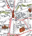
- excerpt from PHARUS city map of Frankfurt, late 1920s.
- The map shows Eschenheim Gate in the north, Hauptwache (today Frankfurt's central subway hub) and Zeil (main shopping street) and the city's main post office (destroyed 1944) in the south, St.Peter's church in the northeastern and Börse (Frankfurt Stock Exchange) on the western edge of the map.
- scanned and uploaded by: Magadan
- License: public domain
- Beschreibung: Ausschnitt aus dem Frankfurter Pharus-Stadtplan.
- Der Ausschnitt zeigt die Gegend um das Eschenheimer Tor und reicht im Süden bis zur Hauptwache und zur Zeil. Links sieht man die Frankfurter Wertpapierbörse.
- Der Titel der Vorlage ist: PHARUS PLAN Frankfurt a. M.; mit Straßenverzeichnis; Schul-Ausgabe. Der Plan trägt kein Ausgabejahr.
- Anhand der verzeichneten Objekte datiere ich den Plan auf das Ende der 20er Jahre.
- Gescannt und eingestellt von: Magadan
- Lizenzstatus: gemeinfrei bzw. Urheberrecht abgelaufen
| Public domainPublic domainfalsefalse |
|
This work is in the public domain in its country of origin and other countries and areas where the copyright term is the author's life plus 70 years or fewer. Note that a few countries have copyright terms longer than 70 years: Mexico has 100 years, Jamaica has 95 years, Colombia has 80 years, and Guatemala and Samoa have 75 years. This image may not be in the public domain in these countries, which moreover do not implement the rule of the shorter term. Honduras has a general copyright term of 75 years, but it does implement the rule of the shorter term. Copyright may extend on works created by French who died for France in World War II (more information), Russians who served in the Eastern Front of World War II (known as the Great Patriotic War in Russia) and posthumously rehabilitated victims of Soviet repressions (more information).
| |
| This file has been identified as being free of known restrictions under copyright law, including all related and neighboring rights. | |
https://creativecommons.org/publicdomain/mark/1.0/PDMCreative Commons Public Domain Mark 1.0falsefalse
File history
Click on a date/time to view the file as it appeared at that time.
| Date/Time | Thumbnail | Dimensions | User | Comment | |
|---|---|---|---|---|---|
| current | 11:03, 3 May 2005 |  | 439 × 498 (329 KB) | Magadan (talk | contribs) | Stadtplanausschnitt Frankfurt am Main, PD |
You cannot overwrite this file.
File usage on Commons
The following 2 pages use this file:
File usage on other wikis
The following other wikis use this file:
- Usage on de.wikipedia.org
- Usage on ro.wikipedia.org
Metadata
This file contains additional information such as Exif metadata which may have been added by the digital camera, scanner, or software program used to create or digitize it. If the file has been modified from its original state, some details such as the timestamp may not fully reflect those of the original file. The timestamp is only as accurate as the clock in the camera, and it may be completely wrong.
| _error | 0 |
|---|
