File:Nieuw Nederland and Nya Sverige.svg

Original file (SVG file, nominally 835 × 1,215 pixels, file size: 457 KB)
Captions
Captions
Summary
edit| DescriptionNieuw Nederland and Nya Sverige.svg |
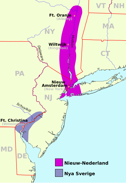
Deutsch: Karte von Neu-Niederland und Neu-Schweden um 1650
English: Map of New-Nederland and New-Sweden ca. 1650
Nederlands: Kaart van Nieuw-Nederland en Nieuw-Zweden rond 1650
Svenska: Karta över Nya Nederländerna och Nya Sverige, ca 1650 |
||
| Date | (UTC) | ||
| Source | |||
| Author | |||
| SVG development InfoField | This map was created with a text editor.
|
| See also: Nya Sverige |
- You are free:
- to share – to copy, distribute and transmit the work
- to remix – to adapt the work
- Under the following conditions:
- attribution – You must give appropriate credit, provide a link to the license, and indicate if changes were made. You may do so in any reasonable manner, but not in any way that suggests the licensor endorses you or your use.
- share alike – If you remix, transform, or build upon the material, you must distribute your contributions under the same or compatible license as the original.
Original upload log
editThis image is a derivative work of the following images:
- File:Nieuw Nederland and Nya Sverige.png licensed with PD-self
- 2009-06-26T05:03:23Z Bogomolov.PL 420x640 (13010 Bytes) CO => CT for the Connecticut
- 2005-08-31T18:56:56Z Arnapha 420x640 (9857 Bytes) Map of New-Nederland and New-Sweden ca. 1650 Created on base of the maps of Delaware, New Jersey, and New York from the Perry Castañeda Library (at http://www.lib.utexas.edu/maps/united_states.html). Transferred from Germa
- File:USA New Jersey location map.svg licensed with Cc-by-3.0, GFDL
- 2009-06-17T19:59:27Z Alexrk2 839x1560 (259806 Bytes) enh
- 2009-06-13T18:01:16Z Alexrk 839x1560 (198653 Bytes) fixed SVG bug
- 2009-06-13T17:46:17Z Alexrk 839x1560 (246056 Bytes) == Beschreibung == {{Information |Description= {{de|Positionskarte von [[:de:New Jersey|New Jersey]], [[:de:USA|USA]]}} Quadratische Plattkarte, N-S-Streckung 130.0 %. Geographische Begrenzung der Karte: * N: 41.6° N * S: 38
- File:USA New York location map.svg licensed with Cc-by-3.0, GFDL
- 2009-06-10T11:28:20Z NordNordWest 1572x1277 (597043 Bytes) {{Information |Description= {{de|Positionskarte vom Bundesstaat [[:de:New York (Bundesstaat)|New York]], [[:de:USA|USA]]}} Quadratische Plattkarte, N-S-Streckung 135 %. Geographische Begrenzung der Karte: * N: 45.3° N * S: 4
- File:USA Delaware location map.svg licensed with Cc-by-3.0, GFDL
- 2009-06-22T10:54:18Z Alexrk2 470x800 (106507 Bytes) renderer bug
- 2009-06-22T10:39:54Z Alexrk2 470x800 (66078 Bytes) == Beschreibung == {{Information |Description= {{de|Positionskarte von [[:de:Delaware|Delaware]], [[:de:USA|USA]]}} Quadratische Plattkarte, N-S-Streckung 130.0 %. Geographische Begrenzung der Karte: * N: 40.0° N * S: 38.3°
Uploaded with derivativeFX
File history
Click on a date/time to view the file as it appeared at that time.
| Date/Time | Thumbnail | Dimensions | User | Comment | |
|---|---|---|---|---|---|
| current | 18:42, 5 January 2022 |  | 835 × 1,215 (457 KB) | Marnanel (talk | contribs) | Fix markup error |
| 18:38, 5 January 2022 |  | 835 × 1,215 (457 KB) | Marnanel (talk | contribs) | Ft. Orange -> Ft. Oranje (Dutch spelling) | |
| 07:01, 1 January 2011 |  | 835 × 1,215 (460 KB) | Arnapha (talk | contribs) | corrected state borders | |
| 06:29, 1 January 2011 |  | 845 × 1,225 (460 KB) | Arnapha (talk | contribs) | moved origin | |
| 06:26, 1 January 2011 |  | 845 × 1,225 (460 KB) | Arnapha (talk | contribs) | use total viewBox | |
| 05:01, 1 January 2011 |  | 1,520 × 1,780 (460 KB) | Arnapha (talk | contribs) | SVG version of Nieuw_Nederland_and_Nya_Sverige.png | |
| 22:52, 19 September 2007 |  | 420 × 640 (31 KB) | Cronholm144 (talk | contribs) | {{Information |Description=made based on png of the same name |Source=self-made |Date= |Author= Cronholm144 }} |
You cannot overwrite this file.
File usage on Commons
The following 6 pages use this file:
File usage on other wikis
The following other wikis use this file:
- Usage on af.wikipedia.org
- Usage on ar.wikipedia.org
- Usage on arz.wikipedia.org
- Usage on azb.wikipedia.org
- Usage on bg.wikipedia.org
- Usage on cs.wikipedia.org
- Usage on de.wikipedia.org
- Usage on el.wikipedia.org
- Usage on en.wikipedia.org
- New Jersey
- New Sweden
- Samuel Blommaert
- Province of New Jersey
- Talk:New Sweden
- History of Pennsylvania
- Peach War
- History of New Jersey
- Colonial history of New Jersey
- Portal:New Jersey
- Willem Usselincx
- List of colonial governors of New Jersey
- Portal:Pennsylvania
- Territorial evolution of North America prior to 1763
- Swedish South Company
- John Hansson Steelman
- Hans Månsson
- User:Falcaorib/Canada, United States and Mexico
- Usage on es.wikipedia.org
- Usage on et.wikipedia.org
- Usage on fa.wikipedia.org
- Usage on fi.wikipedia.org
- Usage on fr.wikipedia.org
- Usage on fy.wikipedia.org
- Usage on he.wikipedia.org
- Usage on hy.wikipedia.org
- Usage on it.wikipedia.org
- Usage on ja.wikipedia.org
View more global usage of this file.
Metadata
This file contains additional information such as Exif metadata which may have been added by the digital camera, scanner, or software program used to create or digitize it. If the file has been modified from its original state, some details such as the timestamp may not fully reflect those of the original file. The timestamp is only as accurate as the clock in the camera, and it may be completely wrong.
| Width | 835px |
|---|---|
| Height | 1215px |