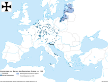
File:Templerorden in Europa 1300.png

Original file (2,500 × 1,906 pixels, file size: 668 KB, MIME type: image/png)
Captions
Captions
Summary
edit| DescriptionTemplerorden in Europa 1300.png |
Deutsch: Die Niederlassungen des Templerordens in Europa um 1300. Karte aus der Saisonausstellung 2008 im Ritterhaus Bubikon, Schweiz ("Die Kreuzzüge eine Spurensuche: Die Ritterorden in der Schweiz"). |
| Date | 5.1.2009 |
| Source | Own work, Karte nach: Grosser Historischer Weltatlas. Bayrischer Schulbuch-Verlag (Hg.). Bd. 2, Mittelalter. München 1970, S. 82. |
| Author | Marco Zanoli (sidonius (talk) 20:42, 5 January 2009 (UTC)) |
| Other versions |
  |
Licensing
editYou may use my work outside wikipedia for free as long as you name me as the author. If you would like to use my work in a print medium, please send me a specimen copy.
Contact me if you have questions regarding the license or if you want individual changes to the map (marco.zanoli at hotmail.ch). This file is licensed under the Creative Commons Attribution-Share Alike 4.0 International license. Attribution: Marco Zanoli
|
File history
Click on a date/time to view the file as it appeared at that time.
| Date/Time | Thumbnail | Dimensions | User | Comment | |
|---|---|---|---|---|---|
| current | 09:09, 20 November 2022 |  | 2,500 × 1,906 (668 KB) | Gyalu22 (talk | contribs) | Small corrections in accordance to other maps |
| 12:52, 6 November 2020 |  | 2,500 × 1,906 (673 KB) | Claude Zygiel (talk | contribs) | Added Dniepr, small correction of borderlines cca 1300, following the Westermann Atlas zur Weltgeschischte (cited in legend) | |
| 02:00, 10 April 2017 |  | 2,500 × 1,906 (606 KB) | Santasa99 (talk | contribs) | Small correction of river and border lines, seen on the map in blue and light gray. (v. 14th c.; 1300 cca) | |
| 17:52, 15 July 2014 |  | 2,500 × 1,906 (224 KB) | Kopiersperre (talk | contribs) | optipng | |
| 17:19, 31 January 2011 |  | 2,500 × 1,906 (502 KB) | Conveyance (talk | contribs) | Die Flüsse Drau und Save, die Klöster in Ljubljana (Laibach) und Zdelja, sowie die Kirchen in Orahovica und Nasice eingezeichnet. | |
| 11:03, 7 January 2011 |  | 2,500 × 1,906 (222 KB) | Sidonius (talk | contribs) | Oder eingezeichnet, Kommenden östlich der Oder ergänzt | |
| 05:05, 4 July 2010 |  | 2,500 × 1,902 (355 KB) | DcoetzeeBot (talk | contribs) | Remove watermark, add author and license data to image metadata, decrease filesize with pngcrush | |
| 20:59, 5 January 2009 |  | 2,500 × 1,902 (593 KB) | Sidonius (talk | contribs) | {{Information |Description={{de|1=Die Niederlassungen des Templerordens in Europa um 1300. Karte aus der Saisonausstellung 2008 im Ritterhaus Bubikon, Schweiz ("Die Kreuzzüge eine Spurensuche: Die Ritterorden in der Schweiz").}} |Source=Own work, Karte n |
You cannot overwrite this file.
File usage on Commons
The following 7 pages use this file:
File usage on other wikis
The following other wikis use this file:
- Usage on an.wikipedia.org
- Usage on bg.wikipedia.org
- Usage on cs.wikipedia.org
- Usage on de.wikipedia.org
- Usage on el.wikipedia.org
- Usage on en.wikipedia.org
- Usage on es.wikipedia.org
- Usage on fr.wikipedia.org
- Usage on it.wikipedia.org
- Usage on ko.wikipedia.org
- Usage on nl.wikipedia.org
- Usage on pl.wikipedia.org
- Usage on pt.wikipedia.org
- Usage on sk.wikipedia.org
- Usage on sl.wikipedia.org
- Usage on www.wikidata.org
Metadata
This file contains additional information such as Exif metadata which may have been added by the digital camera, scanner, or software program used to create or digitize it. If the file has been modified from its original state, some details such as the timestamp may not fully reflect those of the original file. The timestamp is only as accurate as the clock in the camera, and it may be completely wrong.
| Horizontal resolution | 37.79 dpc |
|---|---|
| Vertical resolution | 37.79 dpc |