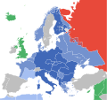
File:World War II in Europe, 1942.svg

Size of this PNG preview of this SVG file: 519 × 488 pixels. Other resolutions: 255 × 240 pixels | 511 × 480 pixels | 817 × 768 pixels | 1,089 × 1,024 pixels | 2,178 × 2,048 pixels.
Original file (SVG file, nominally 519 × 488 pixels, file size: 674 KB)
File information
Structured data
Captions
Captions
Europe at the height of Axis success, 1942.
Europa en 1942.
Summary
edit| DescriptionWorld War II in Europe, 1942.svg |
English: Europe at the height of Axis success
Español: Europa en 1942. |
| Date | |
| Source |
Own work This file was derived from: |
| Author | Goran tek-en |
| Other versions |
[edit]
|
This W3C-unspecified vector image was created with Inkscape .
Licensing
editThis file is licensed under the Creative Commons Attribution-Share Alike 4.0 International license.
Attribution: Goran tek-en
- You are free:
- to share – to copy, distribute and transmit the work
- to remix – to adapt the work
- Under the following conditions:
- attribution – You must give appropriate credit, provide a link to the license, and indicate if changes were made. You may do so in any reasonable manner, but not in any way that suggests the licensor endorses you or your use.
- share alike – If you remix, transform, or build upon the material, you must distribute your contributions under the same or compatible license as the original.
File history
Click on a date/time to view the file as it appeared at that time.
| Date/Time | Thumbnail | Dimensions | User | Comment | |
|---|---|---|---|---|---|
| current | 19:14, 28 December 2015 |  | 519 × 488 (674 KB) | Goran tek-en (talk | contribs) | Missed one island. Denmark: "Nominally unoccupied" changed to "Areas under German occupation". Sources https://en.wikipedia.org/wiki/Denmark_in_World_War_II en:Denmark in World War II. [[https://en.wikipedia.org/wiki/Talk:Sweden_during_World_War_II... |
| 19:05, 28 December 2015 |  | 519 × 488 (674 KB) | Goran tek-en (talk | contribs) | Denmark: "Nominally unoccupied" changed to "Areas under German occupation". Sources [https://en.wikipedia.org/wiki/Denmark_in_World_War_II en:Denmark in World War II]. [https://en.wikipedia.org/wiki/Talk:Sweden_during_World_War_II#Denmark_in_illustrati... | |
| 22:30, 14 June 2015 |  | 519 × 488 (675 KB) | AxG (talk | contribs) | "Independant" > "Independent" | |
| 15:45, 25 April 2015 |  | 519 × 488 (674 KB) | Goran tek-en (talk | contribs) | dotted border | |
| 14:41, 25 April 2015 |  | 519 × 488 (672 KB) | Goran tek-en (talk | contribs) | dotted border between Germany proper | |
| 19:40, 20 March 2015 |  | 519 × 488 (679 KB) | DIREKTOR (talk | contribs) | Colours per other images in this scheme + grey for inland waters. | |
| 09:47, 20 March 2015 |  | 519 × 488 (677 KB) | Goran tek-en (talk | contribs) | User created page with UploadWizard |
You cannot overwrite this file.
File usage on Commons
The following 22 pages use this file:
- Third Reich
- User:Goran tek-en/Gallery/2015
- User:Magog the Ogre/Maps of conflicts/2015 April
- User:Magog the Ogre/Maps of conflicts/2015 December
- User:Magog the Ogre/Maps of conflicts/2015 June
- User:Magog the Ogre/Maps of conflicts/2015 March
- Commons:Graphic Lab/Map workshop/Archive/2019
- File:Europe, 1942.svg
- File:Europe under Nazi domination-el.png
- File:Europe under Nazi domination.png
- File:World War II in Europe, 1942-pt.svg
- File:World War II in Europe, 1942-zh.svg
- File:World War II in Europe, 1942.svg
- File:World War II in Europe, 1942 (Korean).svg
- File:World War II in Europe, 1942 (no labels).svg
- Template:Other versions/World War II in Europe, 1942
- Category:Maps of Europe under Nazi occupation
- Category:Maps of Nazi Germany
- Category:Nazi Germany
- Category:Nazi collaboration
- Category:Police of Nazi Germany
- Category:Reichspräsidenten (Third Reich)
File usage on other wikis
The following other wikis use this file:
- Usage on ar.wikipedia.org
- Usage on arz.wikipedia.org
- Usage on ast.wikipedia.org
- Usage on az.wikipedia.org
- Usage on be-tarask.wikipedia.org
- Usage on bg.wikipedia.org
- Usage on bn.wikipedia.org
- Usage on bn.wikibooks.org
- Usage on bs.wikipedia.org
- Usage on bxr.wikipedia.org
- Usage on ca.wikipedia.org
- Usage on cdo.wikipedia.org
- Usage on ce.wikipedia.org
- Usage on ckb.wikipedia.org
- Usage on cs.wikipedia.org
- Usage on de.wikipedia.org
- Usage on en.wikipedia.org
- Central Europe
- History of Germany
- Nazi Germany
- 1942
- Puppet state
- German Reich
- Eastern Front (World War II)
- Historiography of World War II
- Joel Brand
- List of national border changes (1914–present)
- Territorial evolution of Germany
- Key events of the 20th century
- Talk:Territory of the Military Commander in Serbia/Archive 3
- Wikipedia:WikiProject Military history/News/January 2012/Book reviews
- User:Vivaporius/Books/Nazi Germany
- Wikipedia:Graphics Lab/Map workshop/Archive/Jun 2015
- Wikipedia:Wikipedia Signpost/2018-06-29/Arbitration report
- Wikipedia:Wikipedia Signpost/Single/2018-06-29
- Wikipedia:Wikipedia Signpost/2018-07-31/Arbitration report
- Wikipedia:Wikipedia Signpost/Single/2018-07-31
View more global usage of this file.
Metadata
This file contains additional information such as Exif metadata which may have been added by the digital camera, scanner, or software program used to create or digitize it. If the file has been modified from its original state, some details such as the timestamp may not fully reflect those of the original file. The timestamp is only as accurate as the clock in the camera, and it may be completely wrong.
| Width | 518.50262 |
|---|---|
| Height | 488.10895 |


