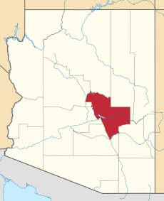
Category:Gila County, Arizona
county in Arizona, United States | |||||
| Upload media | |||||
| Instance of | |||||
|---|---|---|---|---|---|
| Named after | |||||
| Location | Arizona | ||||
| Capital | |||||
| Inception |
| ||||
| Population |
| ||||
| Area |
| ||||
| official website | |||||
 | |||||
English: Media related to Gila County, Arizona, a county in central Arizona, United States.
Subcategories
This category has the following 21 subcategories, out of 21 total.
B
F
G
H
N
O
P
R
S
T
Media in category "Gila County, Arizona"
The following 50 files are in this category, out of 50 total.
-
2013-365-233 Lassie Get Help, Alan is in a Well! (9568928782).jpg 3,968 × 2,976; 4.46 MB
-
2017-365-365 Rising 2018 - Setting on 2017 - Flickr - cogdogblog.jpg 4,032 × 1,650; 994 KB
-
AZSR87inAug1970.JPG 1,087 × 986; 90 KB
-
Bank of East Verde River.jpg 1,429 × 1,067; 630 KB
-
Closure sign.jpg 5,344 × 3,006; 5.12 MB
-
Col. Devon trail from rim - panoramio.jpg 3,264 × 2,448; 3.9 MB
-
Dig This Action (2169915554).jpg 640 × 480; 43 KB
-
Dude fire, 22 years later - panoramio.jpg 10,800 × 2,386; 16.39 MB
-
Fire road near Rim Trail - panoramio.jpg 3,264 × 2,448; 4.41 MB
-
From Nantes Rim - panoramio.jpg 3,072 × 2,304; 1.27 MB
-
Gila County, AZ, USA - panoramio (11).jpg 3,264 × 2,448; 2.41 MB
-
Gila County, AZ, USA - panoramio (9).jpg 3,264 × 2,448; 2.36 MB
-
Grapevine Airstrip (88AZ) on the Phoenix Sectional Chart.png 311 × 283; 251 KB
-
It Was So Clean Before I Rode (9720085529).jpg 3,968 × 2,976; 3.7 MB
-
Jeep Crossing Upper Salt River (4978730018).jpg 4,752 × 3,168; 7.34 MB
-
Jeeps in a Shady Campground (4978729134).jpg 3,894 × 4,364; 9.92 MB
-
Jeeps Near Upper Salt River (4978728598).jpg 3,089 × 2,059; 3 MB
-
Jeeps Near Upper Salt River 2 (4978120549).jpg 4,752 × 3,168; 7.29 MB
-
Lakeside (180470613).jpeg 2,048 × 1,366; 244 KB
-
Landscapes From The Sky 1 (233067381).jpeg 2,048 × 1,365; 444 KB
-
Landscapes From The Sky 2 (233067383).jpeg 2,048 × 1,365; 396 KB
-
Landscapes From The Sky 4 (233067541).jpeg 2,048 × 1,365; 838 KB
-
Menacing Cloud is Moving Towards Me (9720074251).jpg 3,968 × 2,976; 4.05 MB
-
Mountains and Saguaro (4185771219).jpg 3,899 × 2,207; 2.9 MB
-
Near Carrizo, AZ, US 60-SR 77,2011 - panoramio.jpg 4,000 × 3,000; 4.86 MB
-
Near Cibecue, AZ, Moving Day, 2011 - panoramio.jpg 4,000 × 3,000; 5.06 MB
-
Near Heber, AZ, Arizona State Route 260, 2011 - panoramio.jpg 2,560 × 1,920; 2.68 MB
-
Near Heber, AZ, Under the Tonto Rim, 2011 - panoramio.jpg 2,560 × 1,920; 3.03 MB
-
Petrophila longipennis.jpg 1,953 × 2,000; 1.18 MB
-
Road to the Horizon (4393797546).jpg 784 × 588; 275 KB
-
Rock and Grass (4468879496).jpg 3,694 × 2,318; 4.77 MB
-
Rough, steep trail to the top of the rim. - panoramio.jpg 3,264 × 2,448; 4.56 MB
-
Snow fog - panoramio.jpg 3,264 × 2,448; 3.98 MB
-
Tellebration 2013 Storytellers (11023434666).jpg 5,009 × 2,273; 3.29 MB
-
The Storm (153655331).jpeg 2,048 × 908; 398 KB
-
Upper Salt River 1 (4978123769).jpg 4,446 × 4,711; 8.88 MB
-
Upper Salt River 2 (4978731510).jpg 5,150 × 4,988; 11.08 MB
-
Upper Salt River 3 (4978730972).jpg 5,194 × 5,216; 9.85 MB
-
Upper Salt River 4 (4978730556).jpg 4,393 × 3,054; 4.5 MB
-
USA Gila County, Arizona age pyramid.svg 520 × 600; 7 KB
-
View from a Cave on Little Diamond Rim - panoramio.jpg 3,264 × 2,448; 2.62 MB
-
View from top of Little Diamond Rim - panoramio.jpg 3,264 × 2,448; 3.81 MB
-
View to the north - panoramio (2).jpg 1,600 × 1,200; 378 KB
-
View to the northwest - panoramio.jpg 1,600 × 1,200; 361 KB
-
View to the west - panoramio (1).jpg 1,600 × 1,200; 332 KB
-
Wagon Wheel Fire aftermath - panoramio.jpg 3,264 × 2,448; 4.56 MB
-
Wilderness to the north - panoramio.jpg 1,600 × 1,200; 367 KB


