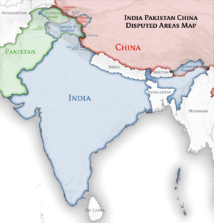
Bereizmen handikoa (SVG fitxategia, nominaldi 1.500 × 1.615 pixel, fitxategiaren tamaina: 1,23 MB)

Fitxategi hau Wikimedia Commonsekoa da. Hango deskribapen orriko informazioa behean duzu.
Commons gordailu bat da, lizentzia askea duten multimedia fitxategiena. Lagun dezakezu.

Fitxategi hau Wikimedia Commonsekoa da

Laburpena

Deskribapena
English: Location map of India.

Equirectangular projection. Strechted by 106.0%. Geographic limits of the map:

  • N: 37.5° N
  • S: 5.0° N
  • W: 67.0° E
  • E: 99.0° E
Made with Natural Earth. Free vector and raster map data @ naturalearthdata.com.
Data
Jatorria Norberak egina
Egilea Uwe Dedering at alemana Wikipedia
Beste bertsioak

Derivative works of this file:

[aldatu]

Lizentzia

Uwe Dedering at alemana Wikipedia, lan honen egileak, argitaratu du edo argitaratzen du ondorengo lizentzia hauen pean:
GNU head Baimena duzu dokumentu hau kopiatu, banatu edo/eta aldatzeko GNU Free Documentation License baldintzapean, Free Software Foundationek argitaratutako 1.2 edo ondorengo bertsioan; sekzio aldaezinik gabe, azaleko testurik gabe, eta atzeko azaleko testurik gabe. Lizentziaren kopia dago GNU Free Documentation License izenburudun atalean.
w:eu:Creative Commons
eskuduntza berdin partekatu
Fitxategi hau Creative Commons Attribution-Share Alike 3.0 Unported lizentziapean dago.
Askea zara:
  • partekatzeko – lana kopiatzeko, banatzeko eta bidaltzeko
  • birnahasteko – lana moldatzeko
Ondorengo baldintzen pean:
  • eskuduntza – Egiletza behar bezala aitortu behar duzu, lizentzia ikusteko esteka gehitu, eta ea aldaketak egin diren aipatu. Era egokian egin behar duzu hori guztia, baina inola ere ez egileak zure lana edo zure erabilera babesten duela irudikatuz.
  • berdin partekatu – Lan honetan oinarrituta edo aldatuta berria eraikitzen baduzu, emaitza lana hau bezalako lizentzia batekin argitaratu behar duzu.
w:eu:Creative Commons
eskuduntza berdin partekatu
This file is licensed under the Creative Commons Attribution-Share Alike 3.0 Germany license.
Askea zara:
  • partekatzeko – lana kopiatzeko, banatzeko eta bidaltzeko
  • birnahasteko – lana moldatzeko
Ondorengo baldintzen pean:
  • eskuduntza – Egiletza behar bezala aitortu behar duzu, lizentzia ikusteko esteka gehitu, eta ea aldaketak egin diren aipatu. Era egokian egin behar duzu hori guztia, baina inola ere ez egileak zure lana edo zure erabilera babesten duela irudikatuz.
  • berdin partekatu – Lan honetan oinarrituta edo aldatuta berria eraikitzen baduzu, emaitza lana hau bezalako lizentzia batekin argitaratu behar duzu.
Nahiago duzun lizentzia erabil dezakezu.

Depiction of India's borders

  • The territorial boundaries of India are shown as per the actual ground situation in accordance with international practices followed by the United Nations and the National Geographic Society
  • This map is meant to be for illustrative purpose only and is not authenticated by official government sources. Please check the list of sources and references used to create the map for a measure of accuracy and verifiability.
  • The usage of these maps in India, Pakistan and China are governed by different laws that restrict depictions of boundaries other than what is officially recognized by the state. Please check local laws and modify the map accordingly before use.

Explanation of disputed boundaries

  • Boundary of Indian claim : The territory India claims is legally theirs, but the claim is disputed by China and Pakistan.
  • Line of Control/Line of Conflict : The de facto administrative boundary recognised by the international community. This UN ceasefire line is considered as a temporary solution to an ongoing conflict since the departure of the British Raj.

Borders of disputed regions

The extent of the former territory of the British Indian Empire, seceeded by Republic of India depicted on this map may not be accepted by most countries as legal due to ongoing border disputes:

  • The northern Himalayan region of the disputed territory Indian-administered Kashmir is claimed by India including (Pakistan-administered Kashmir) and the Chinese Occupied territory of (Ladakh plateau). It is currently divided between all three countries since 1972. See also Line of Control and Line of Actual Control.
  • Siachen glacier (shown white) is an actively contested region between India and Pakistan. At present the region is in control of India since 1984.
  • The northeastern territory of Arunachal Pradesh is almost entirely claimed by China as part of its Tibetan territory.
  • Minor areas of eastern Ladakh, Himachal Pradesh and Uttarakhand on the Chinese frontier are claimed by China. These areas are under Indian control.
  • A small area of Uttarakhand adjoining the Nepal border along the Sarda river is disputed between the two countries.

For a detailed map of all disputed regions in South Asia, see Image:India disputed areas map.svg

Internal borders

The borders of the state of Meghalaya, Assam and Arunachal Pradesh are shown as interpreted from the North-Eastern Areas (Reorganisation) Act, 1971, but has yet to be verified.

Territorial waters

The limit of the territorial waters of India extends to twelve nautical miles measured from the appropriate baseline. See this archive copy at the Wayback Machine for more information.

Jatorrizko igoera erregistroa

Transferred from de.wikipedia to Commons by Uwe Dedering.

The original description page was here. All following user names refer to de.wikipedia.
  • 2010-02-21 16:39 Uwe Dedering 1500×1615× (2412750 bytes) {{Information |Beschreibung = very little borders style changes |Quelle = |Urheber = |Datum = |Genehmigung = |Andere Versionen = |Anmerkungen = }}
  • 2010-02-21 14:16 Uwe Dedering 1500×1615× (2411518 bytes) {{Information |Beschreibung = North now 37.5, changed disputed areas |Quelle = |Urheber = |Datum = |Genehmigung = |Andere Versionen = |Anmerkungen = }}
  • 2010-02-20 16:44 Uwe Dedering 1500×1540× (2246850 bytes) {{Information |Beschreibung = Location map of India. Equirectangular projection. Strechted by 106.0%. Geographic limits of the map: * N: 36.0° N * S: 5.0° N * W: 67.0° E * E: 99.0° E Made with Natural Earth. Free vector and raster map data @ nat

Irudi-oineko testuak

Add a one-line explanation of what this file represents

Fitxategi honetan agertzen diren itemak

honako hau irudikatzen du

20 otsaila 2010

Fitxategiaren historia

Data/orduan klik egin fitxategiak orduan zuen itxura ikusteko.

(Azkenekoak | Lehenbizikoak) Ikusi (berriagoak diren 10) () (10 | 20 | 50 | 100 | 250 | 500).
Data/OrduaIruditxoaNeurriakErabiltzaileaIruzkina
oraingoa10:24, 4 apirila 202110:24, 4 apirila 2021 bertsioaren iruditxoa1.500 × 1.615 (1,23 MB)TKsdik8900Fulfilling the edit request (File talk:India location map.svg#Upload more compact version of India location map) by C1MM
17:50, 14 urria 202017:50, 14 urria 2020 bertsioaren iruditxoa1.500 × 1.615 (1,64 MB)NordNordWestcorrect Telangana/Andhra Pradesh
00:10, 4 azaroa 201900:10, 4 azaroa 2019 bertsioaren iruditxoa1.500 × 1.615 (1,62 MB)RaviCslight colour change for consistency
00:06, 4 azaroa 201900:06, 4 azaroa 2019 bertsioaren iruditxoa1.500 × 1.615 (1,62 MB)RaviC== {{int:filedesc}} == {{Information |Description={{en|Location map of India. Equirectangular projection. Strechted by 106.0%. Geographic limits of the map: * N: 37.5° N * S: 5.0° N * W: 67.0° E * E: 99.0° E Made with Natural Earth. Free vector and raster map data @ naturalearthdata.com.}} |Source={{own}} |Date=2010-02-20 |Author={{user at project|Uwe Dedering|wikipedia|de}} |Permission= |other_versions={{DerivativeVersions|India location map2.svg|India location map 3.png}} {{Other versions/I...
22:42, 19 abuztua 201422:42, 19 abuztua 2014 bertsioaren iruditxoa1.500 × 1.615 (1,59 MB)M0ttyUpdate by Sémhur : add the state of Telangana
12:51, 7 ekaina 201112:51, 7 ekaina 2011 bertsioaren iruditxoa1.500 × 1.615 (1,49 MB)NordNordWestNagaland corrected
17:10, 18 urtarrila 201117:10, 18 urtarrila 2011 bertsioaren iruditxoa1.500 × 1.615 (2,36 MB)Uwe DederingReverted to version as of 15:50, 17 January 2011 and again, layer structure destroyed, and first discuss this!
20:04, 17 urtarrila 201120:04, 17 urtarrila 2011 bertsioaren iruditxoa1.500 × 1.615 (1,52 MB)AshwiniKalantriThe disputed land of Kashmir are shown in a different shade.
16:50, 17 urtarrila 201116:50, 17 urtarrila 2011 bertsioaren iruditxoa1.500 × 1.615 (2,36 MB)Uwe DederingReverted to version as of 11:34, 22 September 2010 vandalism
00:30, 17 urtarrila 201100:30, 17 urtarrila 2011 bertsioaren iruditxoa1.500 × 1.615 (2,01 MB)AshwiniKalantri{{Information |Description=Location Map of India |Source= |Date= |Author= |Permission= |other_versions= }}
(Azkenekoak | Lehenbizikoak) Ikusi (berriagoak diren 10) () (10 | 20 | 50 | 100 | 250 | 500).

Fitxategiaren erabilera orokorra

Metadatuak

  NODES
admin 3
COMMUNITY 1
INTERN 4
Project 4