Africa-regions.png (၃၆၀ × ၃၉၂ pixels, ဖိုင်အရွယ်အစား - ၈ KB, MIME အမျိုးအစား image/png)

အကျဉ်းချုပ်

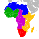
Africa: subregions as delineated by United Nations geographic classification scheme:

 
physiographically, country with partial territory in Western AsiaEgypt (Sinai Peninsula)

လိုင်စင်သတ်မှတ်ခြင်း

ကျွန်ုပ်၊ ဤလုပ်ဆောင်ချက်၏ မူပိုင်ခွင့်ပိုင်ရှင်အနေဖြင့် ဤနေရာမှ အောက်ပါလိုင်စင်များအောက်တွင် ထုတ်လွှင့်ပါသည်:
GNU head ဤစာတမ်းကို GNU Free Documentation License, ဗားရှင်း ၁.၂ သို့မဟုတ် Free Software Foundation မှ ဖြန့်ချီထားသော မည်သည့်ယခင်ဗားရှင်းတစ်ခုခုအောက်တွင် Invariant Sections, Front-Cover Texts နှင့် Back-Cover Texts များမပါဝင်ဘဲ ကူးယူခြင်း၊ ဖြန့်ချီခြင်း နှင့်/သို့မဟုတ် ပြင်ဆင်ပြောင်းလဲနိုင်ရန် ခွင့်ပြုသည်။ လိုင်စင်မူပွားကို GNU Free Documentation License ခေါင်းစဉ်အောက်တွင် ထည့်သွင်းထားသည်။
w:my:Creative Commons
မှတ်ယူနိုင်ခြင်း ထပ်တူမျှဝေ
ဤဖိုင်ကို Creative Commons Attribution-Share Alike 3.0 Unported လိုင်စင်ဖြင့် သတ်မှတ်ထားသည်။
သင်သည် လွတ်လပ်စွာ:
  • မျှဝေရန် – ဖန်တီးမှုကို ကူးယူရန်၊ ဖြန့်ဖြူးရန်နှင့် ထုတ်လွှင့်ရန်
  • ပြန်ရောနှောရန် – ဖန်တီးမှုကို ပြင်ဆင်ညှိနှိုင်းရန်
အောက်ပါ အခြေအနေများတွင်:
  • မှတ်ယူနိုင်ခြင်း – ပြောင်းလဲမှုများ ပြုလုပ်ခဲ့ပါက ဖန်တီးသူ သို့မဟုတ် လိုင်စင်ရှိသူမှ သတ်မှတ်သော အမျိုးအစားကို လိုက်နာရမည် (ဆိုလိုသည်မှာ သင့်အား သို့မဟုတ် သင့်ဖန်တီးမှုတွင် အသုံးပြုခြင်းအား ထောက်ခံချက်ပေးသည်ဟု မဆိုလိုပါ)။
  • ထပ်တူမျှဝေ – ဤဖန်တီးမှုအား ပြင်ဆင်ခြင်း၊ ပြောင်းလဲခြင်း သို့မဟုတ် ထပ်ဆင့် ဖန်တီးခြင်း ပြုလုပ်ပါက ရရှိလာသော ဖန်တီးမှုကို ဤဖန်တီးမှုနှင့် သို့မဟုတ် ဆင်တူသော လိုင်စင်ဖြင့်သာ ဖြန့်ချိသင့်သည်။
This licensing tag was added to this file as part of the GFDL licensing update.
w:my:Creative Commons
မှတ်ယူနိုင်ခြင်း ထပ်တူမျှဝေ
ဤဖိုင်သည် Creative Commons Attribution-Share Alike 2.5 Generic, 2.0 Generic and 1.0 Generic လိုင်စင်အောက်တွင် လိုင်စင်သတ်မှတ်ထားပါသည်။
သင်သည် လွတ်လပ်စွာ:
  • မျှဝေရန် – ဖန်တီးမှုကို ကူးယူရန်၊ ဖြန့်ဖြူးရန်နှင့် ထုတ်လွှင့်ရန်
  • ပြန်ရောနှောရန် – ဖန်တီးမှုကို ပြင်ဆင်ညှိနှိုင်းရန်
အောက်ပါ အခြေအနေများတွင်:
  • မှတ်ယူနိုင်ခြင်း – ပြောင်းလဲမှုများ ပြုလုပ်ခဲ့ပါက ဖန်တီးသူ သို့မဟုတ် လိုင်စင်ရှိသူမှ သတ်မှတ်သော အမျိုးအစားကို လိုက်နာရမည် (ဆိုလိုသည်မှာ သင့်အား သို့မဟုတ် သင့်ဖန်တီးမှုတွင် အသုံးပြုခြင်းအား ထောက်ခံချက်ပေးသည်ဟု မဆိုလိုပါ)။
  • ထပ်တူမျှဝေ – ဤဖန်တီးမှုအား ပြင်ဆင်ခြင်း၊ ပြောင်းလဲခြင်း သို့မဟုတ် ထပ်ဆင့် ဖန်တီးခြင်း ပြုလုပ်ပါက ရရှိလာသော ဖန်တီးမှုကို ဤဖန်တီးမှုနှင့် သို့မဟုတ် ဆင်တူသော လိုင်စင်ဖြင့်သာ ဖြန့်ချိသင့်သည်။
သင်အလိုရှိရာ လိုင်စင်ကို ရွေးချယ်နိုင်ပါသည်။
File:Africa-regions.svg is a vector version of this file. It should be used in place of this PNG file when not inferior.

File:Africa-regions.png → File:Africa-regions.svg

For more information, see Help:SVG.

In other languages
Alemannisch  العربية  беларуская (тарашкевіца)  български  বাংলা  català  нохчийн  čeština  dansk  Deutsch  Ελληνικά  English  British English  Esperanto  español  eesti  euskara  فارسی  suomi  français  Frysk  galego  Alemannisch  עברית  hrvatski  magyar  հայերեն  Bahasa Indonesia  Ido  italiano  日本語  ქართული  한국어  lietuvių  македонски  മലയാളം  Bahasa Melayu  norsk bokmål  Plattdüütsch  Nederlands  norsk nynorsk  norsk  occitan  polski  prūsiskan  português  português do Brasil  română  русский  sicilianu  Scots  slovenčina  slovenščina  српски / srpski  svenska  தமிழ்  ไทย  Türkçe  татарча / tatarça  українська  vèneto  Tiếng Việt  中文  中文(中国大陆)  中文(简体)  中文(繁體)  中文(马来西亚)  中文(新加坡)  中文(臺灣)  中文(臺灣)  +/−
New SVG image

ပုံစာများ

ဤဖိုင်၏ဆိုလိုရင်းကို စာတစ်ကြောင်းရှင်းလင်းချက်ဖြင့် ထည့်သွင်းရန်

Items portrayed in this file

depicts အင်္ဂလိပ်

media type အင်္ဂလိပ်

image/png

checksum အင်္ဂလိပ်

99e24847dfc7d308c007e19664bcafb5a4453b92

determination method or standard အင်္ဂလိပ်: SHA-1

data size အင်္ဂလိပ်

၇၉၅၉ ဘိုက်

height အင်္ဂလိပ်

၃၉၂ pixel

width အင်္ဂလိပ်

၃၆၀ pixel

ဖိုင်မှတ်တမ်း

ဖိုင်ကို ယင်းနေ့စွဲ အတိုင်း မြင်နိုင်ရန် နေ့စွဲ/အချိန် တစ်ခုခုပေါ်တွင် ကလစ်နှိပ်ပါ။

(အသစ်ဆုံး | အဟောင်းဆုံး) (ပိုသစ်သော ၁၀ ခု | ) အထိကြား ရလဒ် (၁၀ | ၂၀ | ၅၀ | ၁၀၀ | ၂၅၀ | ၅၀၀) ခုကို ကြည့်ရန်
နေ့စွဲ/အချိန်နမူနာပုံငယ်မှတ်တမ်း ဒိုင်မန်းရှင်းများအသုံးပြုသူမှတ်ချက်
ကာလပေါ် ၀၂:၀၂၊ ၁ ဇွန် ၂၀၁၈ ၀၂:၀၂၊ ၁ ဇွန် ၂၀၁၈ ရက်က မူအတွက် နမူနာပုံငယ်၃၆၀ × ၃၉၂ (၈ KB)VesperiusReverted to version as of 18:36, 28 May 2018 (UTC) (Most definitions of the regions include the Horn of Africa as part of East Africa, so I'm reverting this back)
၁၈:၃၇၊ ၂၈ မေ ၂၀၁၈ ၁၈:၃၇၊ ၂၈ မေ ၂၀၁၈ ရက်က မူအတွက် နမူနာပုံငယ်၃၆၀ × ၃၉၂ (၁၀ KB)VesperiusReverted to version as of 18:25, 28 May 2018 (UTC) (Messed up, the purple indicating the Horn of Africa didn't show up for me)
၁၈:၃၆၊ ၂၈ မေ ၂၀၁၈ ၁၈:၃၆၊ ၂၈ မေ ၂၀၁၈ ရက်က မူအတွက် နမူနာပုံငယ်၃၆၀ × ၃၉၂ (၈ KB)VesperiusReverted to version as of 01:04, 16 May 2018 (UTC)
၁၈:၂၅၊ ၂၈ မေ ၂၀၁၈ ၁၈:၂၅၊ ၂၈ မေ ၂၀၁၈ ရက်က မူအတွက် နမူနာပုံငယ်၃၆၀ × ၃၉၂ (၁၀ KB)VesperiusReverted to version as of 18:57, 17 March 2018 (UTC)
၀၁:၀၄၊ ၁၆ မေ ၂၀၁၈ ၀၁:၀၄၊ ၁၆ မေ ၂၀၁၈ ရက်က မူအတွက် နမူနာပုံငယ်၃၆၀ × ၃၉၂ (၈ KB)DwoReverted to version as of 08:22, 30 August 2015 (UTC)
၁၈:၅၇၊ ၁၇ မတ် ၂၀၁၈ ၁၈:၅၇၊ ၁၇ မတ် ၂၀၁၈ ရက်က မူအတွက် နမူနာပုံငယ်၃၆၀ × ၃၉၂ (၁၀ KB)MaphobbyistMontenegro border
၀၈:၂၂၊ ၃၀ ဩဂုတ် ၂၀၁၅ ၀၈:၂၂၊ ၃၀ ဩဂုတ် ၂၀၁၅ ရက်က မူအတွက် နမူနာပုံငယ်၃၆၀ × ၃၉၂ (၈ KB)Wiki-ZyronReverted to version as of 00:23, 20 December 2012 - Reverted to the last version before someone inexplicably moved Zimbabwe to Southern Africa. Eastern Africa is the correct region - [http://unstats.un.org/unsd/methods/m49/m49regin.htm#africa]
၀၅:၀၄၊ ၂၁ ဧပြီ ၂၀၁၅ ၀၅:၀၄၊ ၂၁ ဧပြီ ၂၀၁၅ ရက်က မူအတွက် နမူနာပုံငယ်၃၆၀ × ၃၉၂ (၁၆ KB)TAKASUGI ShinjiCorrected the color of Zimbabwe
၁၅:၁၆၊ ၁၈ ဒီဇင်ဘာ ၂၀၁၄ ၁၅:၁၆၊ ၁၈ ဒီဇင်ဘာ ၂၀၁၄ ရက်က မူအတွက် နမူနာပုံငယ်၃၆၀ × ၃၉၂ (၁၇ KB)Hybscherwrong colors
၂၂:၃၉၊ ၂၂ နိုဝင်ဘာ ၂၀၁၄ ၂၂:၃၉၊ ၂၂ နိုဝင်ဘာ ၂၀၁၄ ရက်က မူအတွက် နမူနာပုံငယ်၂၀၀၀ × ၂၀၅၀ (၃၄၂ KB)Andrew J.Kurbikopp
(အသစ်ဆုံး | အဟောင်းဆုံး) (ပိုသစ်သော ၁၀ ခု | ) အထိကြား ရလဒ် (၁၀ | ၂၀ | ၅၀ | ၁၀၀ | ၂၅၀ | ၅၀၀) ခုကို ကြည့်ရန်

အောက်ပါ စာမျက်နှာ သည် ဤဖိုင်ကို အသုံးပြုထားသည်:

ဂလိုဘယ် ဖိုင်သုံးစွဲမှု

အောက်ပါ အခြားဝီကီများတွင် ဤဖိုင်ကို အသုံးပြုထားသည်-

ဤဖိုင်ကို အခြားနေရာများတွင် အသုံးပြုထားမှုများအား ကြည့်ရှုရန်။

  NODES