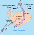
Bestand:Iceland Mid-Atlantic Ridge map.svg

Afmetingen van deze voorvertoning van het type PNG van dit SVG-bestand: 376 × 390 pixels Andere resoluties: 231 × 240 pixels | 463 × 480 pixels | 740 × 768 pixels | 987 × 1.024 pixels | 1.974 × 2.048 pixels.
Oorspronkelijk bestand (SVG-bestand, nominaal 376 × 390 pixels, bestandsgrootte: 129 kB)
Bestandsgeschiedenis
Klik op een datum/tijd om het bestand te zien zoals het destijds was.
| Datum/tijd | Miniatuur | Afmetingen | Gebruiker | Opmerking | |
|---|---|---|---|---|---|
| huidige versie | 10 jan 2014 19:48 |  | 376 × 390 (129 kB) | Amitchell125 | text improved |
| 26 feb 2010 15:42 |  | 376 × 390 (68 kB) | Beao | Tweak. | |
| 26 feb 2010 15:40 |  | 376 × 390 (68 kB) | Beao | Tweak. | |
| 26 feb 2010 15:37 |  | 376 × 390 (68 kB) | Beao | == Summary == {{Information |Description={{en|1=Map showing the Mid-Atlantic Ridge splitting Iceland and separating the North American and Eurasian Plates. The map also shows Reykjavik, the capital of Iceland, the Thingvellir area, and the locations of so |
Bestandsgebruik
Dit bestand wordt op de volgende 4 pagina's gebruikt:
Globaal bestandsgebruik
De volgende andere wiki's gebruiken dit bestand:
- Gebruikt op be-tarask.wikipedia.org
- Gebruikt op bn.wikipedia.org
- Gebruikt op ca.wikipedia.org
- Gebruikt op en.wikipedia.org
- Gebruikt op en.wikivoyage.org
- Gebruikt op fi.wikipedia.org
- Gebruikt op hr.wikipedia.org
- Gebruikt op id.wikipedia.org
- Gebruikt op it.wikipedia.org
- Gebruikt op ko.wikipedia.org
- Gebruikt op lb.wikipedia.org
- Gebruikt op no.wikipedia.org
- Gebruikt op pl.wikipedia.org
- Gebruikt op simple.wikipedia.org
- Gebruikt op sl.wikipedia.org
- Gebruikt op sr.wikipedia.org
- Gebruikt op sv.wikipedia.org
- Gebruikt op tr.wikipedia.org
- Gebruikt op uk.wikipedia.org
- Gebruikt op zh.wikipedia.org
- Gebruikt op zh.wikivoyage.org


