Building facade reconstruction by fusing terrestrial laser points and images
- PMID: 22408539
- PMCID: PMC3291924
- DOI: 10.3390/s90604525
Building facade reconstruction by fusing terrestrial laser points and images
Abstract
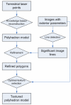
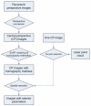
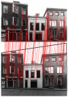
Laser data and optical data have a complementary nature for three dimensional feature extraction. Efficient integration of the two data sources will lead to a more reliable and automated extraction of three dimensional features. This paper presents a semiautomatic building facade reconstruction approach, which efficiently combines information from terrestrial laser point clouds and close range images. A building facade's general structure is discovered and established using the planar features from laser data. Then strong lines in images are extracted using Canny extractor and Hough transformation, and compared with current model edges for necessary improvement. Finally, textures with optimal visibility are selected and applied according to accurate image orientations. Solutions to several challenge problems throughout the collaborated reconstruction, such as referencing between laser points and multiple images and automated texturing, are described. The limitations and remaining works of this approach are also discussed.
Keywords: building reconstruction; data fusion; terrestrial laser scanning; texturing.
Figures


Similar articles
-
Terrestrial and aerial laser scanning data integration using wavelet analysis for the purpose of 3D building modeling.Sensors (Basel). 2014 Jul 7;14(7):12070-92. doi: 10.3390/s140712070. Sensors (Basel). 2014. PMID: 25004157 Free PMC article.
-
Hough Transform and Clustering for a 3-D Building Reconstruction with Tomographic SAR Point Clouds.Sensors (Basel). 2019 Dec 5;19(24):5378. doi: 10.3390/s19245378. Sensors (Basel). 2019. PMID: 31817536 Free PMC article.
-
Fusion of UAV-based infrared and visible images for thermal leakage map generation of building facades.Heliyon. 2023 Mar 15;9(3):e14551. doi: 10.1016/j.heliyon.2023.e14551. eCollection 2023 Mar. Heliyon. 2023. PMID: 36967944 Free PMC article.
-
Long-Standing Themes and Future Prospects for the Inspection and Maintenance of Façade Falling Objects from Tall Buildings.Sensors (Basel). 2022 Aug 14;22(16):6070. doi: 10.3390/s22166070. Sensors (Basel). 2022. PMID: 36015831 Free PMC article. Review.
-
Application of Terrestrial Laser Scanning (TLS) in the Architecture, Engineering and Construction (AEC) Industry.Sensors (Basel). 2021 Dec 30;22(1):265. doi: 10.3390/s22010265. Sensors (Basel). 2021. PMID: 35009806 Free PMC article. Review.
Cited by
-
Development of a 3D Underground Cadastral System with Indoor Mapping for As-Built BIM: The Case Study of Gangnam Subway Station in Korea.Sensors (Basel). 2015 Dec 9;15(12):30870-93. doi: 10.3390/s151229833. Sensors (Basel). 2015. PMID: 26690174 Free PMC article.
-
Automated As-Built Model Generation of Subway Tunnels from Mobile LiDAR Data.Sensors (Basel). 2016 Sep 13;16(9):1486. doi: 10.3390/s16091486. Sensors (Basel). 2016. PMID: 27649172 Free PMC article.
-
Line-Based Registration of Panoramic Images and LiDAR Point Clouds for Mobile Mapping.Sensors (Basel). 2016 Dec 31;17(1):70. doi: 10.3390/s17010070. Sensors (Basel). 2016. PMID: 28042855 Free PMC article.
-
A Direct Georeferencing Method for Terrestrial Laser Scanning Using GNSS Data and the Vertical Deflection from Global Earth Gravity Models.Sensors (Basel). 2017 Jun 24;17(7):1489. doi: 10.3390/s17071489. Sensors (Basel). 2017. PMID: 28672795 Free PMC article.
References
-
- Dick A., Torr P., Ruffle S., Cipolla R. Combining single view recognition and multiple view stereo forarchitectural scenes. Eighth IEEE International Conference on Computer Vision, 2001. 2001;1 ICCV 2001. Proceedings.
-
- Schindler K., Bauer J. A model-based method for building reconstruction. First IEEE International Workshop on Higher-Level Knowledge in 3D Modeling and Motion Analysis, 2003. 2003:74–82. HLK 2003.
-
- Frueh C., Jain S., Zakhor A. Data processing algorithms for generating textured 3D building facade meshes from laser scans and camera images. Inter. J. Comput. Vision. 2005;61:159–184.
-
- Becker S., Haala N. Combined Feature Extraction for Façade Reconstruction. Proceedings of the ISPRS Workshop Laser Scanning 2007 and SilviLaser 2007; Espoo, Finland. 12-14 Sept. 2007; pp. 241–247.
-
- Pu S., Vosselman G. Knowledge based reconstruction of building models from terrestrial laser scanning data. ISPRS J. Photogramm. Remote Sens. 2009 In Press, Corrected Proof. - PubMed
LinkOut - more resources
Full Text Sources

