Quantifying the effect of Jacobiasca lybica pest on vineyards with UAVs by combining geometric and computer vision techniques
- PMID: 31009493
- PMCID: PMC6476504
- DOI: 10.1371/journal.pone.0215521
Quantifying the effect of Jacobiasca lybica pest on vineyards with UAVs by combining geometric and computer vision techniques
Abstract
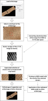
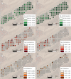
With the increasing competitiveness in the vine market, coupled with the increasing need for sustainable use of resources, strategies for improving farm management are essential. One such effective strategy is the implementation of precision agriculture techniques. Using photogrammetric techniques, the digitalization of farms based on images acquired from unmanned aerial vehicles (UAVs) provides information that can assist in the improvement of farm management and decision-making processes. The objective of the present work is to quantify the impact of the pest Jacobiasca lybica on vineyards and to develop representative cartography of the severity of the infestation. To accomplish this work, computational vision algorithms based on an ANN (artificial neural network) combined with geometric techniques were applied to geomatic products using consumer-grade cameras in the visible spectra. The results showed that the combination of geometric and computational vision techniques with geomatic products generated from conventional RGB (red, green, blue) images improved image segmentation of the affected vegetation, healthy vegetation and ground. Thus, the proposed methodology using low-cost cameras is a more cost-effective application of UAVs compared with multispectral cameras. Moreover, the proposed method increases the accuracy of determining the impact of pests by eliminating the soil effects.
Conflict of interest statement
The authors have declared that no competing interests exist.
Figures


Similar articles
-
Experimenting Agriculture 4.0 with Sensors: A Data Fusion Approach between Remote Sensing, UAVs and Self-Driving Tractors.Sensors (Basel). 2022 Oct 18;22(20):7910. doi: 10.3390/s22207910. Sensors (Basel). 2022. PMID: 36298261 Free PMC article.
-
Deep learning based banana plant detection and counting using high-resolution red-green-blue (RGB) images collected from unmanned aerial vehicle (UAV).PLoS One. 2019 Oct 17;14(10):e0223906. doi: 10.1371/journal.pone.0223906. eCollection 2019. PLoS One. 2019. PMID: 31622450 Free PMC article.
-
A Framework for Agricultural Pest and Disease Monitoring Based on Internet-of-Things and Unmanned Aerial Vehicles.Sensors (Basel). 2020 Mar 8;20(5):1487. doi: 10.3390/s20051487. Sensors (Basel). 2020. PMID: 32182732 Free PMC article.
-
Perspectives for Remote Sensing with Unmanned Aerial Vehicles in Precision Agriculture.Trends Plant Sci. 2019 Feb;24(2):152-164. doi: 10.1016/j.tplants.2018.11.007. Epub 2018 Dec 15. Trends Plant Sci. 2019. PMID: 30558964 Review.
-
Survey and Insights into Unmanned Aerial-Vehicle-Based Detection and Documentation of Clandestine Graves and Human Remains.Hum Biol. 2018 Jan;90(1):45-61. Hum Biol. 2018. PMID: 30387383 Review.
Cited by
-
Advances in Unmanned Aerial System Remote Sensing for Precision Viticulture.Sensors (Basel). 2021 Feb 1;21(3):956. doi: 10.3390/s21030956. Sensors (Basel). 2021. PMID: 33535445 Free PMC article. Review.
-
Bacterial-fungicidal vine disease detection with proximal aerial images.Heliyon. 2024 Jul 8;10(14):e34017. doi: 10.1016/j.heliyon.2024.e34017. eCollection 2024 Jul 30. Heliyon. 2024. PMID: 39108914 Free PMC article.
-
Advances in viticulture via smart phenotyping: current progress and future directions in tackling soil copper accumulation.Front Plant Sci. 2024 Nov 4;15:1459670. doi: 10.3389/fpls.2024.1459670. eCollection 2024. Front Plant Sci. 2024. PMID: 39559771 Free PMC article.
-
Potential of Unmanned Aerial Vehicle Red-Green-Blue Images for Detecting Needle Pests: A Case Study with Erannis jacobsoni Djak (Lepidoptera, Geometridae).Insects. 2024 Mar 4;15(3):172. doi: 10.3390/insects15030172. Insects. 2024. PMID: 38535368 Free PMC article.
-
Insights into the Diversity and Population Structure of Predominant Typhlocybinae Species Existing in Vineyards in Greece.Insects. 2023 Nov 19;14(11):894. doi: 10.3390/insects14110894. Insects. 2023. PMID: 37999093 Free PMC article.
References
-
- FAOSTAT. Agricultural statistical data of Food and Agricultural Organization of the United Nations [Internet]. 2014. Available: http://www.fao.org/faostat/en/#data/QC
-
- MAPAMA. Encuesta sobre superficies y rendimientos de cultivos de España 2016. Resultados Nacionales y Autonómicos MAPAMA, Secretaría General Técnica, Centro de Publicaciones, Catálogo de Publicaciones de la Administración General del Estado, editors. MAPAMA; 2016.
-
- Lentini A, Delrio G, Serra G. Observations on the infestations of Jacobiasca lybica on grapevine in Sardinia. Integrated Control in Viticulture IOBC/wprs Bulletin. 2000;23: 127–129.
-
- Lee WS, Alchanatis V, Yang C, Hirafuji M, Moshou D, Li C. Sensing technologies for precision specialty crop production. Computers and Electronics in Agriculture. 2010;74: 2–33. 10.1016/j.compag.2010.08.005 - DOI
Publication types
MeSH terms
Grants and funding
LinkOut - more resources
Full Text Sources

