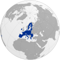
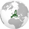
File:European Union (orthographic projection).svg

Original file (SVG file, nominally 792 × 792 pixels, file size: 5.55 MB)

Summary

Description
  • Asturianu: La Xunión Europea ye una organización supranacional nacida el 1 de payares de 1993 col oxetivu d'incrementar la integración económica y política y ameyorar la cooperación ente los sos 27 miembros.
  • Български: Европейският съюз е международна организация, обединяваща 27 европейски държави.
  • Čeština: Evropská unie je mezinárodní organizace 27 evropských států.
  • Dansk: Den Europæiske Union er en international organisation bestående af 27 europæiske lande.
  • Ελληνικά: Η Ευρωπαϊκή Ένωση είναι μια υπερεθνική και διακυβερνητική ένωση 27 κρατών.
  • English: The European Union is an international organisation of 27 European countries.
  • Deutsch: Die Europäische Union ist ein Zusammenschluss 27 europäischer Staaten mit einer Gesamteinwohnerzahl von fast einer halben Milliarde Menschen.
  • Español: Unión Europea es la organización supranacional del ámbito europeo dedicada a incrementar la integración económica y política y a reforzar la cooperación entre sus 27 estados miembros.
  • Français : Union européenne est une organisation internationale, à la fois supranationale et intergouvernementale, qui regroupe vingt-sept États européens.
  • Hrvatski: Europska unija je međunarodna unija 27 europskih država.
  • Հայերեն: Եվրոպական միություն վերպետական և միջկառավարական կազմակերպություն է, որը միավորում է 27 եվրոպական երկրներ՝ նպատակ ունենալով մեծացնել տնտեսական և քաղաքական ինտեգրումը և ամրապնդել անդամ երկրների միջև համագործակցությունը:
  • Italiano: Unione Europea è una organizzazione sovrannazionale e intergovernativa che raggruppa 27 nazioni europee nell'intento di incrementare l'integrazione economica e politica e di rafforzare la cooperazione tra gli stati membri.
  • ქართული: ევროპის კავშირის წევრი ქვეყნების რუკა.
  • ភាសាខ្មែរ: សហភាព​អឺរ៉ុប ឬ EU (ស.អ) គឺ​ជា​អង្គការ​អន្តរជាតិ​មួយ​នៃ​ប្រទេស​ក្នុង​ទ្វីប​អឺរ៉ុប​ ដែល​បច្ចុប្បន្ន​មាន​រដ្ឋ​ជា​សមាជិក​ចំនួន ២៧​។
  • Nederlands: Europese Unie is een internationale organisatie van 27 Europese landen.
  • Polski: Unia Europejska to gospodarczo-polityczny związek 27 państw europejskich, których wspólna liczba ludności wynosi prawie pół miliarda.
  • Magyar: Az Európai Unió részben kormányközi és nemzetekfölötti integráció, amely jelenleg 27 európai országból áll.
  • Português: União Europeia é uma organização internacional constituída por 27 Estados-Membros.
  • Română: Uniunea Europeană este o organizaţie internaţională constituită din 27 de state membre.
  • Slovenčina: Európska únia je medzivládna organziácia 27 európskych štátov.
  • Slovenščina: Evropska unija je medvladna organizacija, ki vključuje 27 evropskih držav in 500 milijonov njihovih prebivalcev.
  • Suomi: Euroopan unioni on kansainvälinen liitto, joka koostuu 27 jäsenvaltiosta.
  • Svenska: Europeiska unionen är en mellanstatlig organisation av europeiska stater, som för närvarande har 28 medlemsstater.
  • Bosanski: Evropska unija je međunarodna unija evropskih država koja trenutno broji 27 država.
  • Brezhoneg: Unaniezh Europa eo anv un aozadur etrebroadel, war un dro etregouarnamantel ha dreistvroadel. Bodañ a ra 27 Stad eus Europa ha 450 milion a dud.
  • Bahasa Indonesia: Uni Eropa adalah organisasi antarabangsa di benua Eropa dengan anggota 27 negara.
  • 日本語: 欧州連合
  • 한국어: 유럽 연합은 유럽 27개국의 국제적인 조직이다.
  • Kurdî: Yekîtiya Ewropayê an jî YE rêxistina navneteweyî ya ku ji 28 welatên Ewropî pêk tê.
  • Македонски: Европската Унија е меѓународна заедница на европски држави која во моментов брои 28 земји.
  • Norsk bokmål: Den europeiske union
  • Русский: Европейский Союз - это международное содружество 27 европейских государств.
  • Српски / srpski: Европска унија је међудржавна организација 27 европских земаља.
  • Türkçe: Avrupa Birliği, 27 Avrupa ülkesinden oluşan uluslararası örgüt.
  • עברית: he:האיחוד האירופי האיחוד האירופי הוא ארגון בין ממשלתי אשר מאגד 27 מדינות באירופה.
Date
Source

Own work,


বাংলা  English  español  français  italiano  日本語  македонски  sicilianu  中文(简体)  中文(繁體)  +/−

GNU head Permission is granted to copy, distribute and/or modify this document under the terms of the GNU Free Documentation License, Version 1.2 or any later version published by the Free Software Foundation; with no Invariant Sections, no Front-Cover Texts, and no Back-Cover Texts. A copy of the license is included in the section entitled GNU Free Documentation License.
Author Heraldry
Permission
(Reusing this file)
This image (or parts of it) was created by this user based on Adobe's Photoshop or Inkscape and probably converted to the portable network graphics format. It is (or includes) one of its different original designs, colours or styles from which you can choose.
You are free to share and make derivative works of the file under the conditions that you appropriately attribute it.
Other versions
This is a Grey & green orthographic projection map.
العربية: الرجاء، قراءة الميثاق.
বাংলা: দয়া করে, রীতিনীতিটি পড়ুন
Deutsch: Bitte lies die Konventionen.
English: Please, read the conventions.
Español: Por favor, lea las convenciones.
Filipino: Paki-basa ang mga kumbensyon.
Français : S'il vous plaît, lisez les conventions.
हिन्दी: कृपया सभागमों को पढ़ लें.
Bahasa Indonesia: Silakan, baca konvensi.
Italiano: Si prega di leggere le convenzioni.
日本語: 規約をご確認ください。
ქართული: გთხოვთ, გაეცნოთ კონვენციებს.
Português: Por favor, leia as convenções.
Русский: Пожалуйста, прочитайте соглашения.
Українська: Будь ласка, прочитайте конвенції.
Tiếng Việt: Hãy đọc công văn trước khi đăng.
中文(繁體):請檢視常規
中文(简体):请查看常规
World maps

Africa

हिन्दी: अफ्रीका
ქართული: აფრიკა.

Eastern Africa

Southern Africa

Central Africa

Northern Africa

Western Africa

Americas

ქართული: ამერიკა.
हिन्दी: अमेरिका

North America

Central America

Caribbean

South America

Asia

ქართული: აზია.
Português: Ásia.
Українська: Азія.

East

Português: Ásia Oriental.
Українська: Східна Азія.

Central

हिन्दी: मध्य एशिया
Português: Ásia Central.
Українська: Центральна Азія.

Southeast

Bahasa Indonesia: Asia tenggara
Português: Sudeste Asiático.

South

(भारतीय उपमहाद्वीप)
Português: Sul da Ásia.
Українська: Південна Азія.

Western

Português: Sudoeste da Ásia.
Українська: Передня Азія.

Europe

हिन्दी: यूरोप
ქართული: ევროპა.
Português: Europa.
Română: Europa.
Русский: Европа.
Українська: Європа.

Countries

Oceania

हिन्दी: ओशिआनिया
ქართული: ოკეანეთი.
Português: Oceania.
Українська: Океанія.

Intercontinental

Português: Intercontinental.
Українська: Міжконтинентальні.

Historical

English: Unions, Organizations, Kingdoms, Empires
Español: Uniones, Organizaciones, Reinos, Imperios
Filipino: Mga Unyon, Organisasyon, Kaharian, Imperyo
Français : Unions, Organisations, Royaumes, Empires
हिन्दी: संघ, संगठन, राज्य, साम्राज्य व ऐतिहासिक देश
ქართული: გაერთიანებები, ორგანიზაციები, სამეფოები, იმპერიები
Português: Estados extintos.
Tagalog: Mga Unyon, Organisasyon, Kaharian, Imperyo
Українська: Союзи, Організації, Королівства, Імперії
中文(繁體):聯盟、組織、王國和帝國
中文(简体):联盟、组织、王国和帝国

Subnationals

हिन्दी: उपराष्ट्रीय इकाईयाँ

Orthographic projections maps created by Heraldry:

SVG development
InfoField
 
The source code of this large SVG is invalid due to 5 errors.
 
This oversized W3C-invalid world map was created with Inkscape…important.

Licensing

I, the copyright holder of this work, hereby publish it under the following license:
GNU head Permission is granted to copy, distribute and/or modify this document under the terms of the GNU Free Documentation License, Version 1.2 or any later version published by the Free Software Foundation; with no Invariant Sections, no Front-Cover Texts, and no Back-Cover Texts. A copy of the license is included in the section entitled GNU Free Documentation License.
w:en:Creative Commons
attribution share alike
This file is licensed under the Creative Commons Attribution-Share Alike 3.0 Unported license.
You are free:
  • to share – to copy, distribute and transmit the work
  • to remix – to adapt the work
Under the following conditions:
  • attribution – You must give appropriate credit, provide a link to the license, and indicate if changes were made. You may do so in any reasonable manner, but not in any way that suggests the licensor endorses you or your use.
  • share alike – If you remix, transform, or build upon the material, you must distribute your contributions under the same or compatible license as the original.
This licensing tag was added to this file as part of the GFDL licensing update.

Captions

Add a one-line explanation of what this file represents

Items portrayed in this file

depicts

image/svg+xml

5,821,069 byte

792 pixel

792 pixel

b098d09dead88e21deeba9694bc160252f2b76ef

File history

Click on a date/time to view the file as it appeared at that time.

Date/TimeThumbnailDimensionsUserComment
current15:26, 15 November 2024Thumbnail for version as of 15:26, 15 November 2024792 × 792 (5.55 MB)Ssolbergj~commonswikiReverted to version as of 08:35, 2 February 2020 (UTC)
08:35, 2 February 2020Thumbnail for version as of 08:35, 2 February 2020792 × 792 (5.55 MB)Rob984Fixed Flevoland in the Netherlands, removed Cyprus buffer zone, and general code cleanup (removing redundant groups etc.)
01:59, 1 February 2020Thumbnail for version as of 01:59, 1 February 2020792 × 792 (5.57 MB)Rob984Restored Western Sahara-Morocco border removed 1 April 2018.
23:46, 31 January 2020Thumbnail for version as of 23:46, 31 January 2020792 × 792 (5.45 MB)Rob984UK and Gibraltar have now left.
06:34, 1 April 2018Thumbnail for version as of 06:34, 1 April 2018792 × 792 (5.46 MB)Giorgi BalakhadzeCorrecting my mistake uploading other map
06:30, 1 April 2018Thumbnail for version as of 06:30, 1 April 2018537 × 536 (341 KB)Giorgi BalakhadzePer COM:OVERWRITE - the original file was without de-facto entities
23:33, 11 July 2014Thumbnail for version as of 23:33, 11 July 2014792 × 792 (5.51 MB)Rob984Improved version: More accurate coastline, borders, etc. Thicker borders. Centred on the centre of the mainland of the European Union.
02:51, 7 September 2009Thumbnail for version as of 02:51, 7 September 2009550 × 550 (508 KB)TownDownbigger
02:28, 7 September 2009Thumbnail for version as of 02:28, 7 September 2009450 × 450 (508 KB)TownDown{{Information |Description={{en|1=x}} |Source=Own work by uploader |Author=TownDown |Date= |Permission= |other_versions= }} Category:x

The following page uses this file:

Global file usage

The following other wikis use this file:

View more global usage of this file.

Metadata

  NODES
design 1
Done 4
eth 5
orte 2
Story 2