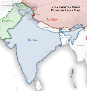
Ôryginalny zbiōr (Zbiōr SVG, nōminalnie 1500 × 1615 pikselōw, srogość zbioru: 1,23 MB)

Tyn zbiōr je ze Wikimedia Commons i może być używany we inkszych projektach. Ôpis na jego zajcie ôpisu zbioru je pokŏzany pod.

Ôpis

Ôpis
English: Location map of India.

Equirectangular projection. Strechted by 106.0%. Geographic limits of the map:

  • N: 37.5° N
  • S: 5.0° N
  • W: 67.0° E
  • E: 99.0° E
Made with Natural Earth. Free vector and raster map data @ naturalearthdata.com.
Data
Zdrzōdło Włŏsnŏ robota
Autōr Uwe Dedering z projektu niymiecki Wikipedyjŏ
Inksze wersyje

Derivative works of this file:

[edytuj]

Licyncyjŏ

Uwe Dedering z projektu niymiecki Wikipedyjŏ – właściciel praw autorskich do tego dzieła, udostępnia je na poniższych licencjach
GNU head Danŏ je zgoda na kopiowanie, rozkludzanie i modyfikowanie tego dokumyntu podle warōnkōw GNU Licencji Wolnej Dokumentacji, we wersyji 1.2 abo nowszyj ôpublikowanyj ôd Free Software Foundation; bez niyzmiynnych sekcyji, bez treści wrażōnych na frōntowõ abo zadniõ zajtã ôbkłŏdki. Kopijŏ licyncyje je wrażōnŏ we sekcyji ze tytułym GNU Licyncyjŏ Swobodnyj Dokumyntacyje.
w:pl:Licencje Creative Commons
uznanie autorstwa trzim licyncyjõ
Idzie:
  • udostympniać – kopiować, rozkludzać i przekazować dzieło
  • modyfikować – adaptować dzieło
Pod tymi warōnkami:
  • uznanie autorstwa – Musisz ôkryślić autorstwo, podać link do licyncyje, i skŏzać, czy dzieło było zmiyniōne. Możesz to zrobić kożdym usōndnym spusobym, ale niy tak, żeby sugerować, że posiedziciel licyncyje spiyrŏ Ciebie abo Twoje użycie dzieła.
  • trzim licyncyjõ – Jeźli zmiyniŏsz abo budujesz na tyj materyji, musisz swoje dzieło rozkludzać na takij samyj abo zgodliwyj licyncyji, jak we ôryginale.
Możesz ôbrać licyncyjõ.

Depiction of India's borders

  • The territorial boundaries of India are shown as per the actual ground situation in accordance with international practices followed by the United Nations and the National Geographic Society
  • This map is meant to be for illustrative purpose only and is not authenticated by official government sources. Please check the list of sources and references used to create the map for a measure of accuracy and verifiability.
  • The usage of these maps in India, Pakistan and China are governed by different laws that restrict depictions of boundaries other than what is officially recognized by the state. Please check local laws and modify the map accordingly before use.

Explanation of disputed boundaries

  • Boundary of Indian claim : The territory India claims is legally theirs, but the claim is disputed by China and Pakistan.
  • Line of Control/Line of Conflict : The de facto administrative boundary recognised by the international community. This UN ceasefire line is considered as a temporary solution to an ongoing conflict since the departure of the British Raj.

Borders of disputed regions

The extent of the former territory of the British Indian Empire, seceeded by Republic of India depicted on this map may not be accepted by most countries as legal due to ongoing border disputes:

  • The northern Himalayan region of the disputed territory Indian-administered Kashmir is claimed by India including (Pakistan-administered Kashmir) and the Chinese Occupied territory of (Ladakh plateau). It is currently divided between all three countries since 1972. See also Line of Control and Line of Actual Control.
  • Siachen glacier (shown white) is an actively contested region between India and Pakistan. At present the region is in control of India since 1984.
  • The northeastern territory of Arunachal Pradesh is almost entirely claimed by China as part of its Tibetan territory.
  • Minor areas of eastern Ladakh, Himachal Pradesh and Uttarakhand on the Chinese frontier are claimed by China. These areas are under Indian control.
  • A small area of Uttarakhand adjoining the Nepal border along the Sarda river is disputed between the two countries.

For a detailed map of all disputed regions in South Asia, see Image:India disputed areas map.svg

Internal borders

The borders of the state of Meghalaya, Assam and Arunachal Pradesh are shown as interpreted from the North-Eastern Areas (Reorganisation) Act, 1971, but has yet to be verified.

Territorial waters

The limit of the territorial waters of India extends to twelve nautical miles measured from the appropriate baseline. See this archive copy at the Wayback Machine for more information.

Oryginalny rejestr przesyłania

Transferred from de.wikipedia to Commons by Uwe Dedering.

The original description page was here. All following user names refer to de.wikipedia.
  • 2010-02-21 16:39 Uwe Dedering 1500×1615× (2412750 bytes) {{Information |Beschreibung = very little borders style changes |Quelle = |Urheber = |Datum = |Genehmigung = |Andere Versionen = |Anmerkungen = }}
  • 2010-02-21 14:16 Uwe Dedering 1500×1615× (2411518 bytes) {{Information |Beschreibung = North now 37.5, changed disputed areas |Quelle = |Urheber = |Datum = |Genehmigung = |Andere Versionen = |Anmerkungen = }}
  • 2010-02-20 16:44 Uwe Dedering 1500×1540× (2246850 bytes) {{Information |Beschreibung = Location map of India. Equirectangular projection. Strechted by 106.0%. Geographic limits of the map: * N: 36.0° N * S: 5.0° N * W: 67.0° E * E: 99.0° E Made with Natural Earth. Free vector and raster map data @ nat

Podpisy

Wyekleruj we jednyj linijce, co tyn zbiōr pokazuje

Obiekty przedstawione na tym zdjęciu

przedstawia polski

Gyszichta zbioru

Kliknij w datã/czas, żeby ôbejzdrzeć zbiōr, jak wtynczŏs wyglōndoł.

(nojnowsze | nojstarsze) Pokŏż (10 nowszych | ) (10 | 20 | 50 | 100 | 250 | 500)
Data i czasMiniaturaWymiaryUżywŏczKōmyntŏrz
terŏźnŏ10:24, 4 kwi 2021Miniatura wersyje 10:24, 4 kwi 20211500 × 1615 (1,23 MB)TKsdik8900Fulfilling the edit request (File talk:India location map.svg#Upload more compact version of India location map) by C1MM
17:50, 14 paź 2020Miniatura wersyje 17:50, 14 paź 20201500 × 1615 (1,64 MB)NordNordWestcorrect Telangana/Andhra Pradesh
00:10, 4 lis 2019Miniatura wersyje 00:10, 4 lis 20191500 × 1615 (1,62 MB)RaviCslight colour change for consistency
00:06, 4 lis 2019Miniatura wersyje 00:06, 4 lis 20191500 × 1615 (1,62 MB)RaviC== {{int:filedesc}} == {{Information |Description={{en|Location map of India. Equirectangular projection. Strechted by 106.0%. Geographic limits of the map: * N: 37.5° N * S: 5.0° N * W: 67.0° E * E: 99.0° E Made with Natural Earth. Free vector and raster map data @ naturalearthdata.com.}} |Source={{own}} |Date=2010-02-20 |Author={{user at project|Uwe Dedering|wikipedia|de}} |Permission= |other_versions={{DerivativeVersions|India location map2.svg|India location map 3.png}} {{Other versions/I...
22:42, 19 siy 2014Miniatura wersyje 22:42, 19 siy 20141500 × 1615 (1,59 MB)M0ttyUpdate by Sémhur : add the state of Telangana
12:51, 7 czy 2011Miniatura wersyje 12:51, 7 czy 20111500 × 1615 (1,49 MB)NordNordWestNagaland corrected
17:10, 18 sty 2011Miniatura wersyje 17:10, 18 sty 20111500 × 1615 (2,36 MB)Uwe DederingReverted to version as of 15:50, 17 January 2011 and again, layer structure destroyed, and first discuss this!
20:04, 17 sty 2011Miniatura wersyje 20:04, 17 sty 20111500 × 1615 (1,52 MB)AshwiniKalantriThe disputed land of Kashmir are shown in a different shade.
16:50, 17 sty 2011Miniatura wersyje 16:50, 17 sty 20111500 × 1615 (2,36 MB)Uwe DederingReverted to version as of 11:34, 22 September 2010 vandalism
00:30, 17 sty 2011Miniatura wersyje 00:30, 17 sty 20111500 × 1615 (2,01 MB)AshwiniKalantri{{Information |Description=Location Map of India |Source= |Date= |Author= |Permission= |other_versions= }}
(nojnowsze | nojstarsze) Pokŏż (10 nowszych | ) (10 | 20 | 50 | 100 | 250 | 500)

Globalne użycie zbioru

Metadane

  NODES
admin 3
COMMUNITY 1
INTERN 4
Project 4